Search Results
Survivor stories: Shooting victims share fight to live - YouTube: archived website, 2017 to 2018
Level of Description
Other Level
Archival Collection
Web Archive on the October 1, 2017 Shooting in Las Vegas, Nevada
To request this item in person:
Collection Number: MS-00866
Collection Name: Web Archive on the October 1, 2017 Shooting in Las Vegas, Nevada
Box/Folder: N/A
Collection Name: Web Archive on the October 1, 2017 Shooting in Las Vegas, Nevada
Box/Folder: N/A
Archival Component
Kappa Xi Chapter of Omega Psi Phi Fraternity, Inc.: archived website, 2021 to 2022
Level of Description
Other Level
Archival Collection
Documenting the African American Experience in Las Vegas, Nevada Web Archive
To request this item in person:
Collection Number: MS-00969
Collection Name: Documenting the African American Experience in Las Vegas, Nevada Web Archive
Box/Folder: N/A
Collection Name: Documenting the African American Experience in Las Vegas, Nevada Web Archive
Box/Folder: N/A
Archival Component
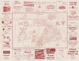
Map of the city of Las Vegas, 1953
Date
1953
Description
24 x 38 cm. on sheet 43 x 56 cm., folded to 28 x 13 cm. Includes advertisements for Las Vegas businesses. Advertisements for Las Vegas businesses, inset map of North Las Vegas, and index on verso. Copyright held by Redwood Pub. Co. Includes inset map of the Strip (U.S. 91 or Los Angeles Highway). Map is irregularly shaped. Original publisher: Redwood Pub. Co..
Image
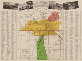
General map of Las Vegas, Nevada, circa 1957
Date
1955 to 1959
Description
'Compiled and issued by the Campbell Realty Company.' At top pf map: ' Greater Las Vegas.' Shows names of housing tracts and locations of hotels and motels on the Las Vegas Strip. Includes indexes and photographs of local recreation and attractions. Originally published by Campbell Realty
distributed by Las Vegas Nevada Chamber of Commerce . Scale (ca. 1:39,000. 1 in. to approx. 3,250 ft.].
distributed by Las Vegas Nevada Chamber of Commerce . Scale (ca. 1:39,000. 1 in. to approx. 3,250 ft.].
Text
Penn National Gaming to Temporarily Suspend Operations at Its Casinos in Nevada: archived website, 2020
Level of Description
Other Level
Archival Collection
UNLV Libraries Collection of Digital Communication about COVID-19 in Las Vegas
To request this item in person:
Collection Number: MS-01031
Collection Name: UNLV Libraries Collection of Digital Communication about COVID-19 in Las Vegas
Box/Folder: N/A
Collection Name: UNLV Libraries Collection of Digital Communication about COVID-19 in Las Vegas
Box/Folder: N/A
Archival Component

Topographic map of Nevada-California, Las Vegas quadrangle, 1951
Date
1951
Description
'Edition of Mar. 1908, reprinted 1951.' 'E.M. Douglas, geographer in charge; Topography and triangulation by R.H. Chapman, B.D. Stewart, J.E. Blackburn, and D.F.C. Moor. Surveyed in 1906-1907.' Scale 1:250,000 ; polyconic proj. (W 116°00--W 115°00/N 37°00--N 36°00). Relief shown by contours and spot heights. Title in lower-right corner: Nev.-Calif., Las Vegas. Contour interval 100 feet. Datum is mean sea level. U.S. Geological Survey
Image

Map showing location of the Las Vegas & Tonopah Railroad from Las Vegas to Bullfrog, Nevada, 1906
Date
1906
Archival Collection
Description
'Office of Chief Engineer' printed on map above date.
Image
Roy, Alec. Pathological Gambling: a Psychobiological Study, Archives of Reference Number Psychiatry, 1988 April
Level of Description
File
Archival Collection
UNLV Libraries Collection of Articles on Gaming and Las Vegas, Nevada Topics
To request this item in person:
Collection Number: MS-00626
Collection Name: UNLV Libraries Collection of Articles on Gaming and Las Vegas, Nevada Topics
Box/Folder: Box 16
Collection Name: UNLV Libraries Collection of Articles on Gaming and Las Vegas, Nevada Topics
Box/Folder: Box 16
Archival Component
Madabhushanam, Sridharan, "Application of asynchronous transfer mode (ATM) technology to picture archiving", 1996 Fall
Level of Description
Item
Archival Collection
University of Nevada, Las Vegas Theses, Dissertations, and Honors Papers
To request this item in person:
Collection Number: UA-00082
Collection Name: University of Nevada, Las Vegas Theses, Dissertations, and Honors Papers
Box/Folder: Box 168
Collection Name: University of Nevada, Las Vegas Theses, Dissertations, and Honors Papers
Box/Folder: Box 168
Archival Component
Traditional Synagogue, Reform Senior Congregation - Temple Bet Knesset Bamidbar: archived website, 2017
Level of Description
Other Level
Archival Collection
Southern Nevada Jewish Heritage Project Web Archive
To request this item in person:
Collection Number: MS-01045
Collection Name: Southern Nevada Jewish Heritage Project Web Archive
Box/Folder: N/A
Collection Name: Southern Nevada Jewish Heritage Project Web Archive
Box/Folder: N/A
Archival Component