Search Results
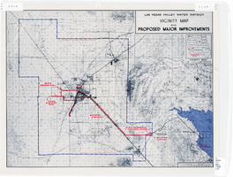
Map showing improvements made to the Las Vegas Valley Water District and vicinity, circa 1950
Date
1946 to 1954
Description
Relief shown by contour lines. Includes inset map showing the location of the Las Vegas Valley Water District Project. In lower left corner: 'Cole...O.' Boundary of Las Vegas Valley Water District marked in dark blue. Scale [ca. 1:126,720. 1 in. to approx. 2 miles
Image
Special Collections and Archives Sexual Entertainment and Economies 2024 launch event and 2025 even featuring Kaitlyn Bailey's "Whore's Eye View" performance: program, advertisement, and set list from Bailey's performance, 2024 to 2025
Level of Description
File
Archival Collection
University of Nevada, Las Vegas University Libraries Records
To request this item in person:
Collection Number: UA-00051
Collection Name: University of Nevada, Las Vegas University Libraries Records
Box/Folder: Box 301
Collection Name: University of Nevada, Las Vegas University Libraries Records
Box/Folder: Box 301
Archival Component
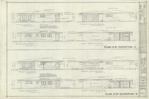
Architectural drawings of residential home in Las Vegas, Nevada, exterior elevations, 1955
Date
1955
Archival Collection
Description
Two different sets of drawings of front, rear, left and right exterior elevations of a ranch-style residential home in the Greater Las Vegas development in Las Vegas, Nevada.
Site Name: Greater Las Vegas
Image
#71954: Hospitality Hall at sunset; Opening reception for the new Built exhibit being installed on the first floor of Lied Library, which highlights the built environment of Las Vegas using images taken by Aaron Mayes and items from our Special Collections & Archives, February 9, 2018, 2018 February 09
Level of Description
Item
Archival Collection
University of Nevada, Las Vegas Creative Services Records (2010s)
To request this item in person:
Collection Number: PH-00388-05
Collection Name: University of Nevada, Las Vegas Creative Services Records (2010s)
Box/Folder: Digital File 01
Collection Name: University of Nevada, Las Vegas Creative Services Records (2010s)
Box/Folder: Digital File 01
Archival Component
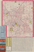
Las Vegas street map and Lake Mead Recreation Area pictorial map, 1979
Date
1979
Description
'Covering Las Vegas, North Las Vegas, Sunrise Manor, Winchester, Paradise and East Las Vegas from Craig Road on the north to Sunset Road on the south and Nellis Boulevard on the east to Jones Boulevard on the west' -- front panel. 'This tourist map has been published by CreaTours, Inc. in co-operation with the North Las Vegas Chamber of Commerce." 3rd ed. Scale [ca. 1:31,680. 1 in. to approx. 0.5 miles]. Includes indexes. Pictorial map of Lake Mead National Recreation Area on verso, by Cliff Segerblom. 'Lithographed by Creel Printing Company, Las Vegas, Nev.' Second edition, copyright 1977. 'Map not to scale due to artistic license.' Advertisements on map verso.
Text
"Philene T. Hall, Bureau of Indian Affairs Field Matron, Planned Culture Change of Washakie Shoshone Women." Prologue Quarterly of the National Archives, vol. 22, no. 2 ( Summer 1990): 151-167, 1990
Level of Description
File
Archival Collection
University of Nevada, Las Vegas Faculty Publications
To request this item in person:
Collection Number: UA-00056
Collection Name: University of Nevada, Las Vegas Faculty Publications
Box/Folder: Box 06
Collection Name: University of Nevada, Las Vegas Faculty Publications
Box/Folder: Box 06
Archival Component

Blueprint map showing proposed water pipeline from Big Spring to Las Vegas, Nevada, January 24, 1911
Date
1911-01-24
Archival Collection
Description
'S.P.L.A.&S.L.R.R. Los Angeles Division. Map of pipe line from Big Spring. Las Vegas, Nev. Approved: Jan. 24, 1911. E.M. Jessup, E.M. of W.' In lower right corner: '4-U-323.' Scale [ca. 1:2,400] 1 in.=200 feet. Relief shown by contours. North is to upper right.
Image

Plan of proposed new well pipe and fittings for Las Vegas, Nevada, 1936
Date
1936
Archival Collection
Description
Blueprint. Written on back of map:: 'Purposed [sic] new transmission lines--1936--transits.' Las Vegas Land and Water Company?
Image

Map of Boulder Dam area and Las Vegas, Nevada, October 7, 1930
Date
1930-10-07
Description
'F.V. Owen, publisher ... Los Angeles, California. Topography by C.H. Fenner, C.E. Decorations by L.J. Bergère. Gov't. data, H.A. Shamberger, C.E. Copyright, 1930, by F.V. Owen.' At bottom right of map: 'Dated Oct. 7th, 1930.' Relief shown by contours and spot heights. Contour lines are 100 feet. Incudes six hand-colored illustrations showing local points of interest. Includes information on Hoover Dam, and chart of mileages from Las Vegas. Scale [ca. 1:63,360]. 1 inch to 1 mile
Text

Map showing profile of 24-inch cast iron water pipeline for Las Vegas, Nevada, May 20, 1930
Date
1930-05-20
Archival Collection
Description
'As constructed. Drawing W.O. - 8577. Office of Chief Engineer, Los Angeles. Drawing No. 41092.' 'Scale for details 1"=10'. 5-20-1930. P.F.D.' 'Scale 1"=100'.' 'Profile of new 24" CI pipe. Scale 1"=600'. Ver. 1"=20'.' Blueprint. Map of the water pipes for Las Vegas. Includes the buildings in the railroad yard, a detailed map of a section of the pipe, a profile of the 24 inch C.I. pipe, and a map of the point of diversion. Date of detailed map is 5-20-1930. Library's copy has hand-written additions in color. Los Angeles & Salt Lake Railroad Co., Office of Chief Engineer,
Image