Search Results

Blueprint showing proposed pipeline for gravity water supply at Las Vegas, Nevada, February 16, 1905
Date
Description
Image
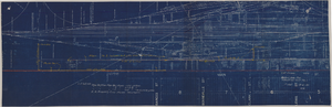
Map showing possible industrial users' connections to railroad pipelines in Las Vegas, Nevada, December 4, 1930
Date
Archival Collection
Description
Stamped portion near lower right corner reads 'Union Pacific System, L.A. & S.L. R.R. Scale: 1" = 100'. Date: 12-4-30. Office Division, Eng'r. Los Angeles. Drg. No. 916.' 10 3/4 in. x 33 3/4 in. Scale: 1" = 100"..
Image
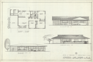
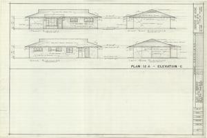
Architectural drawings of residential home in Las Vegas, Nevada, floor plan and three exterior elevations, 1955
Date
Archival Collection
Description
Floor plan and three different front exterior elevation drawings for a ranch-style residential home in the Greater Las Vegas development in Las Vegas, Nevada. Elevations are labeled A, B and C. "10" appears in a circle above the architect's name.
Site Name: Greater Las Vegas
Image
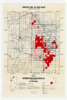
Map showing home-site lands in the Las Vegas Valley, 1955
Date
Description
Image

Blueprint map showing proposed water pipeline from Big Spring to Las Vegas, Nevada, January 24, 1911
Date
Archival Collection
Description
Image
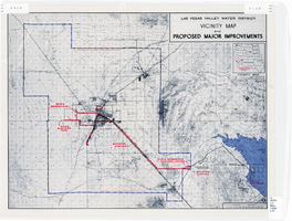
Map showing improvements made to the Las Vegas Valley Water District and vicinity, circa 1950
Date
Description
Image
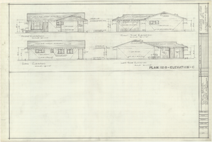
Architectural drawing of residential home in Las Vegas, Nevada, exterior elevations, 1955
Date
Archival Collection
Description
Front, rear, left and right exterior elevations of a ranch-style residential home in the Greater Las Vegas development in Las Vegas, Nevada.
Site Name: Greater Las Vegas
Image
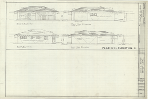
Architectural drawings of residential home in Las Vegas, Nevada, exterior elevations, 1955
Date
Archival Collection
Description
Front, rear, left and right exterior elevations of a ranch-style residential home in the Greater Las Vegas development in Las Vegas, Nevada.
Site Name: Greater Las Vegas
Image

Map showing profile of 24-inch cast iron water pipeline for Las Vegas, Nevada, May 20, 1930
Date
Archival Collection
Description
Image