Search Results
Jacob Wohl on Twitter: "While brave law enforcement heroes save hundreds of lives in Las Vegas, thugs in the NFL continue to slander law enforcement and our flag https://t.co/ZjfJx8eMiH": archived website, 2017
Level of Description
Archival Collection
Collection Name: Web Archive on the October 1, 2017 Shooting in Las Vegas, Nevada
Box/Folder: N/A
Archival Component
Casi 60 muertos y más de 500 heridos en la mayor masacre a tiros de Estados Unidos | Internacional | EL PAÍS: archived website, 2017
Level of Description
Archival Collection
Collection Name: Web Archive on the October 1, 2017 Shooting in Las Vegas, Nevada
Box/Folder: N/A
Archival Component
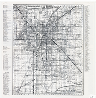
Map of greater Las Vegas area, 1964-1965
Date
Description
Text

Original plat, townsite of Las Vegas, Lincoln Co., Nevada, January 13, 1905
Date
Description
Subtitle: 'Embracing the N. 1/2 of S.W. 1/4 Sec. 27 Township 20S. R.61E. Mt. Diablo Meridian.' 'Book 1, page 17A" handwritten in lower right corner. Signed by Henry Lee, County Recorder, Lincoln County Nevada. 'Filed at request of J.T. Williams, January 13th A.D. 1905.' Backwards handwriting on right side. Map has a Lincoln County seal on the bottom near the center. In the dedication J.T. McWilliams states that he has surveyed and platted the townsite of Las Vegas subject to the right of way of the San Pedro, Los Angeles and Salt Lake Railroad Company. He signed the dedication on Jan. 13, 1905, and it was signed by witnesses Scale [ca. 1:2,520? 1 inch to approx. 210 feet?]. Copy of a blueline print.
Image

Map of the Las Vegas Strip, 1953
Date
Description
Image
"Primary Productivity and Nutrient Balance in a Lower Colorado River Reservoir." Archiv für Hydrobiologie, vol. 94, no. 1 (April 1982): 1-23, 1982
Level of Description
Archival Collection
Collection Name: University of Nevada, Las Vegas Faculty Publications
Box/Folder: Box 04
Archival Component

Map of well locations, Las Vegas Valley, Nevada, 1975
Date
Description
Image

Redevelopment plan map for downtown Las Vegas, Nevada, November 18, 1987
Date
Description
Image

Plat showing original townsite and subdivisions, Las Vegas, Lincoln County, Nevada, May 1905
Date
Description
Land owned by the San Pedro, Los Angeles & Salt Lake Railroad is outlined. Scale: [ca. 1:12,000]. 1 inch = 1,000 feet. Cadastral map. Blueline print. Additional copy available in the J.T. McWilliams manuscript collection
Image
Rascovar, B. 2001. "Region Needs Rail Lines." Baltimore, Maryland: The Baltimore Sun. http://www.sunspot.net/tunnell.fire/sunspot_ne:-archive9.html, 2001
Level of Description
Archival Collection
Collection Name: Environmental Radiation Protection Standards for Yucca Mountain, Nevada
Box/Folder: Box 43
Archival Component