Search Results
Dennis McBride with his queer archive at the University of Nevada, Las Vegas Lied Library Special Collections Department: digital image, 2016 February 29
Level of Description
Archival Collection
Collection Name: Dennis McBride Photograph Collection
Box/Folder: Digital File 00
Archival Component
Nevada Local Government Records Manual by Nevada State Library & Archives, 1988 July 18
Level of Description
Archival Collection
Collection Name: Clark County Planning Commission Research Library Collection
Box/Folder: Box 90
Archival Component
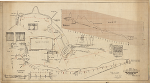
Map showing proposed improvements of Las Vegas Springs, Las Vegas, Nevada, January 26, 1918
Date
Archival Collection
Description
'Exhibit A'. 'Approved Jan. 26, 1918.' Includes discharge figures and plans for improvements to springs for the municipal water system including diagrams of spillway openings, etc. Scale [ca. 1:1200] 1 in.=100 feet -- Scale [ca. 1:120] 1 in.=10 feet -- Scale [ca. 1:240] 1 in.=20 feet -- Scale [ca. 1:24] 1 in.=2 feet -- Scale [ca. 1:2400] 1 in.=200 feet. Vertical scale [ca. 1:48] 1 in.=4 feet -- Scale [ca. 1:12] 1 in.=1 foot.
Image
Nevada State Archives and Records building in Carson City, Nevada: photographic negative, approximately 1985 to 1989
Level of Description
Archival Collection
Collection Name: UNLV Libraries Single Item Accession Photograph Collection
Box/Folder: Box SH-025
Archival Component
Nevada State Library and Archives building in Carson City, Nevada: photographic negative, approximately 1958 to 1989
Level of Description
Archival Collection
Collection Name: UNLV Libraries Single Item Accession Photograph Collection
Box/Folder: Box SH-025
Archival Component

City map of Las Vegas, 1973
Date
Description
Image
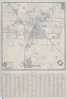
Street map of Las Vegas and vicinity, 1960
Date
Description
Image
BREAKING: Sheriff Says Las Vegas Shooter Could Have Been "Radicalized" » Alex Jones' Infowars: There's a war on for your mind!: archived website, 2017
Level of Description
Archival Collection
Collection Name: Web Archive on the October 1, 2017 Shooting in Las Vegas, Nevada
Box/Folder: N/A
Archival Component
Leftists Celebrate "White Trump Supporters" Being Killed in Las Vegas Massacre » Alex Jones' Infowars: There's a war on for your mind!: archived website, 2017
Level of Description
Archival Collection
Collection Name: Web Archive on the October 1, 2017 Shooting in Las Vegas, Nevada
Box/Folder: N/A
Archival Component
More than 50 dead and 400 injured in shooting on Las Vegas Strip; police say lone suspect is dead – LA Times: archived website, 2017
Level of Description
Archival Collection
Collection Name: Web Archive on the October 1, 2017 Shooting in Las Vegas, Nevada
Box/Folder: N/A
Archival Component