Search Results
Special Collections and Archives Sexual Entertainment and Economies 2024 launch event and 2025 even featuring Kaitlyn Bailey's "Whore's Eye View" performance: program, advertisement, and set list from Bailey's performance, 2024 to 2025
Level of Description
Archival Collection
Collection Name: University of Nevada, Las Vegas University Libraries Records
Box/Folder: Box 301
Archival Component
#71954: Hospitality Hall at sunset; Opening reception for the new Built exhibit being installed on the first floor of Lied Library, which highlights the built environment of Las Vegas using images taken by Aaron Mayes and items from our Special Collections & Archives, February 9, 2018, 2018 February 09
Level of Description
Archival Collection
Collection Name: University of Nevada, Las Vegas Creative Services Records (2010s)
Box/Folder: Digital File 01
Archival Component
"Philene T. Hall, Bureau of Indian Affairs Field Matron, Planned Culture Change of Washakie Shoshone Women." Prologue Quarterly of the National Archives, vol. 22, no. 2 ( Summer 1990): 151-167, 1990
Level of Description
Archival Collection
Collection Name: University of Nevada, Las Vegas Faculty Publications
Box/Folder: Box 06
Archival Component
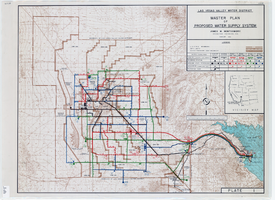
Topographic map of master plan for proposed water supply system for Las Vegas Valley Water District, August 1960
Date
Description
Image
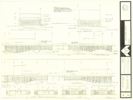
Architectural drawing of concert hall and drama theater, University of Nevada, Las Vegas, exterior elevations, November 5, 1969
Date
Archival Collection
Description
Exterior elevations for the concert hall and drama theater on the University of Nevada, Las Vegas campus, including a connecting courtyard. These buildings would become the Artemus W. Ham Concert Hall and the Judy Bayley Theatre. Sheet 6 of 35. "Drawn by G.T. Checked by K.D. Job number 6828. Scale 1/16" = 1'-0". Date Nov. 5, 1969"
Site Name: University of Nevada, Las Vegas
Address: 4505 S. Maryland Parkway
Image
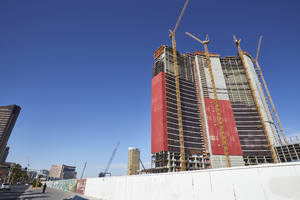
Resorts World Las Vegas as seen from Las Vegas Boulevard, looking southwest in Las Vegas, Nevada: digital photograph
Date
Archival Collection
Description
Photographed as part of the UNLV Special Collections and Archives' Building Las Vegas collecting initiative started in 2016. This photo series documents ongoing construction work at the Resorts World Las Vegas site.
Image
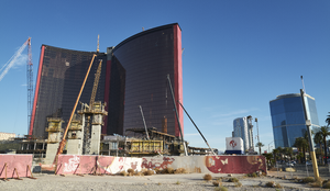
The Resorts World Las Vegas project under construction as seen from near Las Vegas Boulevard with SkyTower Las Vegas Condominiums and the Drew Las Vegas project in background, looking north in Las Vegas, Nevada: digital photograph
Date
Archival Collection
Description
Photographed as part of the UNLV Special Collections and Archives' Building Las Vegas collecting initiative started in 2016. This photo series documents ongoing construction work at the Resorts World Las Vegas site.
Image
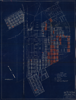
Map showing general plan for the district boundary of Lateral Sanitary Sewer District No. 1, Las Vegas, Nevada, circa 1928
Date
Description
Image
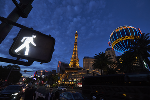
A cross walk indicator frames the Paris Las Vegas Eiffel Tower replica on Las Vegas Boulevard, looking north-northeast in Las Vegas, Nevada: digital photograph
Date
Archival Collection
Description
Photographed as part of the UNLV Special Collections and Archives' Building Las Vegas collecting initiative started in 2016.
Image

General geologic map of Las Vegas, Pahrump, and Indian Spring Valleys, Clark and Nye Counties, Nevada, 1948
Date
Description
At top of map: 'United States Department of the Interior, Geological Survey. State Engineer of Nevada. Water resources bulletin No. 5, Plate 1.' Relief shown by spot heights. Includes 3 inset maps of wells and springs in the vicinity of Pahrump, Manse Ranch and Indian Springs, Nevada. Scale [ca. 1:126,720. 1 inch to approx. 2 miles] (W 116°--W 115°/N 40°--N 36°). Originally published as plate 1 in Geology and water resources of Las Vegas, Pahrump, and Indian Spring Valleys, Clark and Nye Counties, Nevada by George B. Maxey and C.H. Jameson (1948), which is number 5 of the Water resources bulletin published by the Nevada Office of the State Engineer.
Image