Search Results
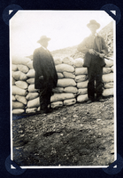
Photograph of men guarding sacked ore at Round Mountain (Nev.), early 1900s
Date
1900 to 1925
Archival Collection
Description
Photograph of men guarding sacked ore at Round Mountain (Nev.), early 1900s
Image

Photograph of men riding in the Desert Maiden automobile, Round Mountain (Nev.), early 1900s
Date
1900 to 1925
Archival Collection
Description
Photograph of men riding in the Desert Maiden automobile, Round Mountain (Nev.), early 1900s
Image
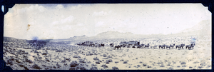
Photograph of packtrains and buggies crossing desert, Tonopah (Nev.), early 1900s
Date
unspecified year in 190X
Archival Collection
Description
Photograph of packtrains and buggies crossing desert, Tonopah (Nev.), early 1900s
Image
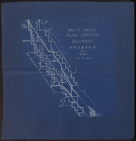
Map of Moapa Valley flood channel drainage program for 1940
Date
1940
Archival Collection
Description
Scale [ca. 1:63,360]. 1 in.=1 mile. Blueprint.
Image
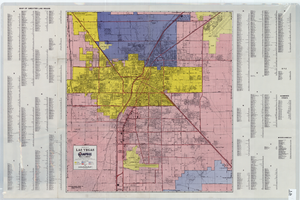
A general map of Las Vegas, 1969
Date
1905-05-22
Description
Color; 60 x 55 cm. on sheet 64 x 96 cm. At top left of map: Map of greater Las Vegas. Includes index.
Image

Map of Moapa River Indian Reservation, TPS. 14 & 15 S., RS. 65 & 66 E., M.D.M., Nevada, 1902
Date
1902
Description
As surveyed by V. S. Barber, 1902. Scale = 15 chains to an inch. "H Doc 65 57 2" in lower right corner. Relief shown by hachures. Shows township and range grid.
Image
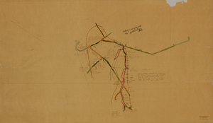
Map of the fifth level of the Clermont Mine, Goldfield, Nevada, circa 1902-1908
Date
1902 to 1908
Description
'Clermont, 5th level, el. 5098.2.' Hand-drawn, hand-colored and annotated map showing the fifth level of the Clermont Mine.
Image
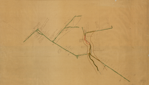
Map of the sixth level of the Clermont Mine, Goldfield, Nevada, circa 1902-1908
Date
1902 to 1908
Description
Hand-drawn, hand-colored and annotated map showing the sixth level of the Claremont Mine. 'Clermont, 6th level, el. 4971.4.'
Image
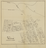
Plat of Tonopah, Nye County, Nevada, circa 1905
Date
1903 to 1907
Description
Plat of properties in downtown Tonopah, Nevada. Notes handwritten in pencil. Southern Nevada Mining Map Collection
Image

Map of underground workings in Potosi and Central Lodes, May 1906
Date
1906-05
Description
'Scale 20 ft = 1 in.'
Image