
Search the Special Collections and Archives Portal

Search Results

Display    Results Per Page
Displaying results 20891 - 20900 of 21778

Map of Las Vegas Valley, Clark County, Nevada, October 1, 1940

Date

1940-10-01

Description

'Compiled by C.D. Baker, Civil Engineer, State Water Right Surveyor, Mineral Surveyor, Gen. Land Office, Las Vegas, Clark County, Nevada. Oct. 1, 1940.' Yellow lines show boundary of the proposed water district; green lines show boundary of the city of Las Vegas; red line shows the Union Pacific Railroad route.

Image

Map of Las Vegas and vicinity, including Henderson and Boulder City, Nevada, 1958

Date

1958

Description

53 x 52 cm. on sheet 56 x 87 cm. Includes inset maps of Boulder City, Henderson, Nellis Air Force Base and Las Vegas area. Map was probably published in 1958 because it shows the Stardust Hotel and Casino, which opened in 1958, but not the Convention Center, which opened in 1959. Includes index. Original publisher: Map Corporation of America.

Image

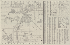
Map of the city of Las Vegas, North Las Vegas, "the Strip," 1960

Date

1960

Description

1960 edition. 41 x 43 cm. Copyright held by Robert E. Barringer. Title in upper-right corner of map: Las Vegas area map. Irregularly-shaped map. Includes index, notes, list of Las Vegas schools and inset maps of East Las Vegas (Whitney) and Wherry housing area on Nellis Air Force Base. Original publisher: Redwood Publishing Co..

Image

Geologic map of the Plutonium Valley quadrangle, Nye and Lincoln counties, Nevada, 1965

Date

1965

Description

58 x 46 cm., on sheet 77 x 83 cm., folded in envelope 30 x 24 cm. Relief shown by contours and spot heights. "Geology mapped in 1961." Includes description of map units, col. cross section, and quadrangle location map. "Prepared in cooperation with the U. S. Atomic Commission." Original publisher: Interior, Geological Survey, Series: Geologic quadrangle map GQ, Scale: 1:24 000.

Image

Geology of the Jackass Flats quadrangle, Nye County, Nevada, 1964

Date

1964

Description

58 x 47 cm., on sheet 86 x 81 cm., folded in envelope 30 x 24 cm. Relief shown by contours and spot heights. "Geology mapped in 1961." Includes description of map units, 2 col. cross sections, and quadrangle location map. "Prepared in cooperation with the U. S. Atomic Commission." Original publisher: Interior, Geological Survey, Series: Geologic quadrangle map GQ, Scale: 1:24 000.

Image

Neeley, Pearl Francis

Alternate Names

Annie Pearl Francis Neeley

Pearl Francis Neeley was a teacher in rural Nevada during the 1920s, where she taught in various schools throughout Lincoln, Nye, and White Pine counties. She was born on July 27, 1901 in Eagle Valley, Nevada, to Selina Corilla Hammond and David Francis.

Person

Kenneth Reim Photographs of Las Vegas, Nevada

Identifier

PH-00309

Abstract

The Kenneth Reim Photographs of Las Vegas, Nevada (1951-1954) consist of seven mounted color 35mm slides that Reim took while living in Las Vegas, Nevada. Images depict the Sands and Sahara hotels, Klein's Market located at Charleston and Main Street, Hoover Dam, a library, Fremont street, and the Las Vegas Park Speedway.

Archival Collection

American Society of Landscape Architects Nevada Chapter Photographs

Identifier

PH-00360

Abstract

The American Society of Landscape Architects Nevada Chapter Photographs (2000-2001) consist of color photographic prints which depict chapter members and leaders at events, including the Pink Flamingo Awards Banquet at the Flamingo Hilton and a lecture series at the University of Nevada, Las Vegas School of Architecture. Other images document strategic planning committee meetings.

Archival Collection