Search Results
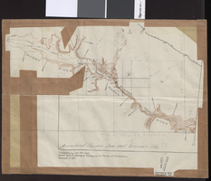
Topographic map of Arrow Canyon dam and reservoir site on the Muddy River, 1934
Date
1934
Archival Collection
Description
'Topography by Lee Morrison. Control by U.S. Geological Survey and U.S. Bureau of Reclamation. Surveyed in 1934.' Relief shown by contours and spot heights. 'Arrowhead Canyon Dam and reservoir site' hand-written on map. Map is part of a larger map and has been taped to a manila envelope sent from the Agricultural Administration to J.H. Wittwer on Sept. 25, 1939. Map has hand-drawn township and range lines and handwritten numbers. Verso has a hand-drawn map, calculations, and hand-written notes. U.S. Geological Survey
Text
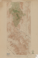
Topographic map of Goodsprings quadrangle, Nevada and California, 1919
Date
1919
Description
'R.B. Marshall, Chief Geographer; Geo. R. Davis, Geographer in charge; Topography by N.E. Ballmer and Roscoe Reeves; Control by J.E. Blackburn and L.F. Biggs. Surveyed in 1915-1916.' 'Edition of 1919.' Relief shown by hachures and spot heights. Title in lower right margin: Goodsprings. In center of top margin: Topography. Includes compilation diagram. Indicates location and density of cedar trees. Shows small portion of San Bernardino County, California. Published by U.S. Geological Survey. Scale 1:62,500 (W 115°35'00"--W 115°24'00"/N 36°02'30"--N 35°42'30"). 'Contour interval 50 feet. Datum is mean sea level.'
Text
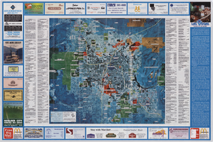
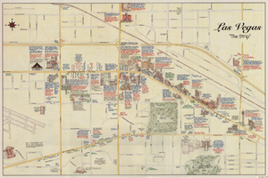
Aerial map of the Las Vegas Valley, with map of Las Vegas, 1992
Date
1992
Description
2 maps on 1 sheet : both sides, col. ; 47 x 51 cm. and 54 x 71 cm. on sheet 61 x 91 cm. Photomap. Includes text about Las Vegas, list of businesses with coordinates for map on verso, and advertisements. On verso: Bird's-eye view map of a section of unincorporated Las Vegas east of the Strip between Charleston and Sunset oriented with north to left and drawn by Jack Tavenner in 1992. Shows locations of schools, lists Boulder City merchants, and includes advertisements. Original Publisher: Landiscor Aerial Photo
Image
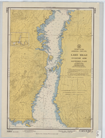
Hydrographic map of Lake Mead, Overton Arm, Southern and Northern Parts
Date
1955-10-17
Description
1st ed., Sept. 1952. Hydrographic chart : color ; 56 x 40 cm. At head of title: United States, Arizona-Nevada. Relief shown by contours, depths shown by soundings. "5458B." "-1952-799." "Catalog page no. 18." On verso: Lake Mead, Overton Arm, southern part. Includes index map. Library's copies have "Compliments of Senator George W. Malone" stamped in red at top on left side. Library's copies have "Corrected through notice to mariners no. 46 Nov. 13 '55" stamped in purple at bottom. Original publisher: U.S. Coast and Geodetic Survey. Scale: 1:48,000
Image
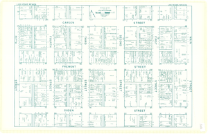
Map of downtown Las Vegas, Nevada, circa 1952-1955
Date
1952 to 1955
Description
Title in upper left and right margins: Las Vegas, Nevada. Identifies business tenants in the downtown area and includes property valuations, measurements, addresses, etc. Cadastral map. Oriented with north to the lower right.Text, illustrations, aerial photos, and ancillary map of the Las Vegas Strip on verso. Cataloger has determined date of map to be between 1952 and 1955 because the Sahara and the Sands Casinos are shown on the verso of the map, and they both opened in 1952, but the Riviera and the Dunes opened in 1955, and they are not shown on the map. Also, the Hotel Last Frontier is shown on the verso of the map, and its name was changed to New Frontier in 1955. Note: Many of the property names and addresses are erroneous when compared to Las Vegas business directories from the same period.
Image
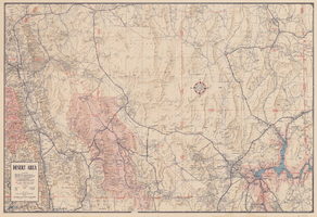
Map of desert area in southern Nevada and southeastern California, circa 1955
Date
1953 to 1957
Description
Covers the desert area in the Owens Valley, Death Valley, Las Vegas and Lake Mead region; bordered by Bishop and Inyokern, California, and Pioche and Lake Mead, Nevada. 'Cartography by W.T. Taylor, W.A. Neely. Color separation by H.P. Pflum; Relief by F.M. Burke; Typography by W.R. Williams. Field mapping by H.A. Cline, G.L. Boyd, K.R. Reed., W.A. Neely, R.P. Conklin.' 'Copyright by Automobile Club of Southern California.' Scale 1:483,537. 1 in. to approx. 8 miles (W 120°--W 114°/N 39°--N 33°). 'Map number 2217.'.
Text

Map of Lincoln County, Nevada and Mohave County, Arizona area, 1892
Date
1892
Description
'Henry Gannett, chief geographer ; A.H. Thompson, geographer in charge ; triangulation by H.M. Wilson ; topography by H.M. Wilson and Powell survey.' 'Edition of Mar. 1892, reprinted 1929.' Handwritten legend on right-side margin of map. Original publisher: Dept. of the Interior, U.S. Geological Survey. Scale 1:250,000
polyconic proj. (W 115°--W 114°/N 37°--N 35°).
polyconic proj. (W 115°--W 114°/N 37°--N 35°).
Image
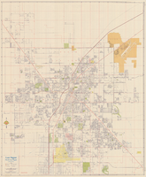
Map of Las Vegas, North Las Vegas, and vicinity, June 1975
Date
1975-06
Description
'Cartographic Department. Copyright by California State Automobile Association. C6-75.' 'Issued by California State Automobile Association and Automobile Club of Southern California. 6-75' on front panel. Indexes on map verso. Scale [ca. 1:32,400. 1 in. to approx. 2700 ft.]. California State Automobile Association.
Text
Maps of the Las Vegas Strip, downtown and metropolitan Las Vegas area, the Grand Canyon and southern Nevada, circa 1997
Date
1995 to 1999
Description
'Detail maps for downtown, neighborhoods, out of town, Grand Canyon' -- front panel. Maps on verso: Downtown -- Out of town and short adventures -- Greater Las Vegas -- Grand Canyon, South Rim Village. Major buildings and points of interest on the Las Vegas Strip shown pictorially. Includes text and notes. Originally published by MapEasy, Inc. Scale [ca. 1:10,560. 1 inch to approximately 1/6 mile].
Text
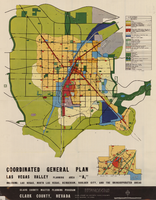
Map showing coordinated general plan for Las Vegas Valley, Planning Area A5, circa 1965-1968
Date
1963 to 1970
Description
Subtitle:'Including Las Vegas, North Las Vegas, Henderson, Boulder City, and the unincorporated areas.' 'Clark County Master Planning Program, Clark County, Nevada.' 'Eisner-Stewart and Associates, Planning Consultants, South Pasadena, California.' Includes inset of Boulder City. Text on verso about the general plan for the Las Vegas Valley, Clark County Master Planning Program Area. Published between 1965 and 1968? Scale [ca. 1:84,269. 1 inch to approximatley 1 1/3 miles].
Text