Search Results
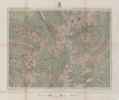
Map of economical features of Southwest Colorado, San Juan mining region, circa 1877
Date
Description
Image
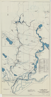
Map and operational diagram, lower Colorado River, Lees Ferry to Gulf of California, May 1957
Date
Description
Image
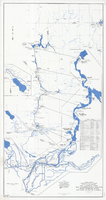
Map and operational diagram, lower Colorado River, Lees Ferry to Gulf of California, June 1973
Date
Description
Image
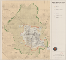
Map showing proposed metropolitan Las Vegas development area, June 24, 1997
Date
Description
Image
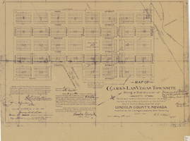
Map of Clark's Las Vegas Townsite, May 8, 1905
Date
Archival Collection
Description
Text

Las Vegas Valley map, Clark County, Nevada, June 1958
Date
Description
Image
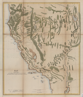
Map showing the different routes travelled over by the detachments of the Overland Command in the spring of 1855 from Salt Lake City, Utah, to the Bay of San Francisco, 1855
Date
Description
Image
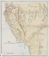
Map showing the different routes travelled over by the detachments of the Overland Command in the spring of 1855 from Salt Lake City, Utah, to the Bay of San Francisco, 1855
Date
Description
Image

Map of economical features of parts of southern Colorado and northern New Mexico, January 8, 1878
Date
Description
37 x 49 cm. Relief shown by hachures and spot heights. "Atlas sheet no. 69(B)." "Issued Jan'y 8th 1878." "Expeditions of 1874-1875 & 1877 under the command of 1st. Lieut. Geo. M. Wheeler, Corps of Engineers, U.S. Army." Prime meridians: Greenwich and Washington, D.C. "Weyss, Lang & Herman, del." "By order of the honorable the Secretary of War." "Under the direction of Brig. General A. A. Hunphreys, Chief of Engineers, U. S. Army." Original publisher: U.S. Geographical Surveys West of the 100th Meridian, Scale: 1 inch to 4 miles or 1: 253440.
Image
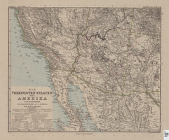
Map of Southwestern United States of America, 1888
Date
Description
Image