Search Results
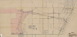
Maps showing sales of water production facilities of the Union Pacific Railroad Company and water distribution facilities of the Las Vegas Land and Water Co. to the Las Vegas Valley Water District, April 29, 1953
Date
1953
Archival Collection
Description
Union Pacific Railroad Co.
Image

Map of California, Nevada, Utah, Colorado, Arizona & New Mexico, circa 1867
Date
1865 to 1869
Description
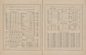
39 x 62 cm. Relief shown by hachures and spot heights. Prime meridian: Greenwich and Washington. Hand colored. Shows natural features, populated places, routes of mail steamships, routes of explorers, locations of Indian tribes, railroad routes, and proposed railroad routes. In top margin: No. 80-81. On verso: New Mexico, Arizona, Colorado, Idaho, Dakota (statistics and other information) and The state of California (statistics and other information). Original publisher: G.W. and C.B. Colton.
Image
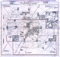
Map of the city of Las Vegas and vicinity, Clark County, Nevada, 1929
Date
1929
Description
'Copyright 1929, C.D. Baker, civil engineer. Drawn by R.C. Kenmir.' Includes inset sketch showing general location of Las Vegas, Nev. Relief shown pictorially on inset map. Scale [ca. 1:39,600. 1 in. to 0.625 mile]. Cadastral map. Library's copy 1 has hand-drawn brown line and red circles. Library's copy 2 has "Proposed annexation" printed in capital letters in red pencil near the top, has a brown line drawn around the area.
Image

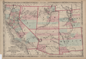
Map of California, territories of New Mexico, Arizona, Colorado, Nevada and Utah, circa 1863
Date
1861 to 1865
Description
40 x 62 cm. Relief shown by hachures and spot heights. Prime meridians: Greenwich and Washington. "Historical and statistical view of the United States, 1860"--Verso. Atlas page numbers at top: 58-59. Arizona became a territory in 1863, and Nevada became a state on October 31, 1864, so this map was either published in 1863 or in 1864 before the end of October. Original publisher: Johnson and Ward.
Image