Search Results

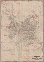


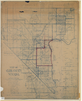
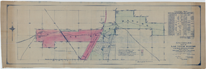
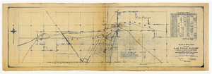
Map of Clark County, Nevada, 1927
Date
1927
Description
'Compiled by J.T. McWilliams from official county records, U.S. Land Dept. surveys, railroad co. field maps and many personal surveys. Made in 1927 by J.T. McWilliams, C.E.' Includes township and road districts, school districts, mining districts, railroads, wagon roads, trails, springs and artesian wells. Scale [ca. 1:316,800. 1 in. to approx. 5 miles] (W 116°--W 114°/N37--N35). Relief shown by hachures. Blueline print. Library's copy 1 has one area outlined by hand in red. Library's copy 2 has school districts outlined in red and green pencil and labeled in pencil by hand.
Image