Search Results
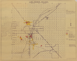
Map of Las Vegas Valley, 1968
Date
1968
Description
'This map compiled by General Drafting Service to show purchases in the Las Vegas area by Howard Hughes and others reported to be affiliated with him.' Shows land owned by Howard Hughes and land owned by Hughes Tool Company. Includes locations of casinos on Las Vegas Strip. Original publisher: General Drafting Service. Scale [ca. 1:48,000]. 1 in. to 4,000 feet. Hand-colored.
Image
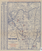
Sketch map of Nevada and the southeastern portion of California, 1906
Date
1906
Description
42 x 29 cm. Relief shown by hachures. Copyright held by George S. Clason. "Compliments of the Patrick Investment Co. ... Denver, Colorado." Includes index. Shows railroad routes. "We have offices, representatives and properties in every camp marked in red on this map." Original publisher: Clason Map Co..
Image
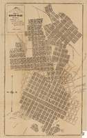
Map of Goldfield, Nevada, April 25, 1907
Date
1907-04-25
Description
'Compiled by James H. Parks, U.S. Deputy Min. Sur., Box 655, Goldfield, Nev. April 25, 1907.' 'Nevada Press Company, Carson City, Nevada.' Scale: [ca. 1:4,800] 1 inch = 400 ft. Plat map. Library's copy has notes handwritten in pencil along right margin with arrows to locations on map: "Ramsey Street ended Columbia St." "MacMaskrs office." "Lived on Euclid ave in adobe house." " Lived in Tent House Sundog Ave."
Image

Map of the city of Las Vegas, North Las Vegas, "the Strip," 1960
Date
1960
Description
1960 edition. 41 x 43 cm. Copyright held by Robert E. Barringer. Title in upper-right corner of map: Las Vegas area map. Irregularly-shaped map. Includes index, notes, list of Las Vegas schools and inset maps of East Las Vegas (Whitney) and Wherry housing area on Nellis Air Force Base. Original publisher: Redwood Publishing Co..
Image