Search Results

Map of California, territories of New Mexico, Arizona, Colorado, Nevada and Utah, circa 1863
Date
1861 to 1865
Description
40 x 62 cm. Relief shown by hachures and spot heights. Prime meridians: Greenwich and Washington. "Historical and statistical view of the United States, 1860"--Verso. Atlas page numbers at top: 58-59. Arizona became a territory in 1863, and Nevada became a state on October 31, 1864, so this map was either published in 1863 or in 1864 before the end of October. Original publisher: Johnson and Ward.
Image
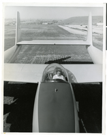
Photograph of Howard Hughes and the XF-11, Culver City, California, July 7, 1946
Date
1946-07-07
Archival Collection
Description
Transcribed from back of photo: "Howard Hughes in the cockpit of the new XF-11 reconnaissance plane which he designed and built in conjuntion with Air Material Command engineers. He is preparing for its first flight. One of the world's fastest long-range photo planes, it can attain a speed of over 400 miles per hour."
Image
Immigration, Congratulations to New Citizens. Contains correspondence, 1961 July to 1961 October
Level of Description
File
Archival Collection
Howard Cannon Papers
To request this item in person:
Collection Number: MS-00002
Collection Name: Howard Cannon Papers
Box/Folder: Box 11 (87th Session)
Collection Name: Howard Cannon Papers
Box/Folder: Box 11 (87th Session)
Archival Component
#72831: UNLV Family Network - New Student Orientation, 2019 July 19
Level of Description
Item
Archival Collection
University of Nevada, Las Vegas Creative Services Records (2010s)
To request this item in person:
Collection Number: PH-00388-05
Collection Name: University of Nevada, Las Vegas Creative Services Records (2010s)
Box/Folder: Digital File 01
Collection Name: University of Nevada, Las Vegas Creative Services Records (2010s)
Box/Folder: Digital File 01
Archival Component
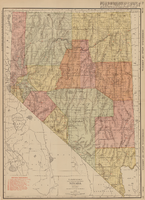
Rand-McNally new commercial atlas map of Nevada, 1912
Date
1912
Description
Original publisher: Rand, McNally & Co. Scale [ca. 1:1,203,840). 1 inch to 19 miles. Originally published as p. 316-317 of Rand McNally's commercial atlas of America. Title in right margin: Nevada : commercial atlas of America. Includes township and range grid. Includes index to Nevada railroads and index to principal cities with their populations. Index on verso to counties, towns and natural features in Oregon and Nevada.
Image
T-Shirt Color: Navy Blue; Front: FDNY 9-11-01; Back: Fallen Brothers Never Forgotten Connecticut Mourn Fire Fighters Fire department City Of New York, Fire Emblem W/Fire Equip, approximately 2001-2012
Level of Description
File
Archival Collection
New York-New York Hotel and Casino 9-11 Heroes Tribute Collection
To request this item in person:
Collection Number: MS-00459
Collection Name: New York-New York Hotel and Casino 9-11 Heroes Tribute Collection
Box/Folder: Box 437
Collection Name: New York-New York Hotel and Casino 9-11 Heroes Tribute Collection
Box/Folder: Box 437
Archival Component
T-Shirt Color: White; Front: Madera Fire Dept. FD; Back: Madera City Firefighters, Fire Engine; Handwritten Text: To New York's Bravest: Our Love And Prayers! - Captain Les + Kim Russell, approximately 2001-2012
Level of Description
File
Archival Collection
New York-New York Hotel and Casino 9-11 Heroes Tribute Collection
To request this item in person:
Collection Number: MS-00459
Collection Name: New York-New York Hotel and Casino 9-11 Heroes Tribute Collection
Box/Folder: Box 241
Collection Name: New York-New York Hotel and Casino 9-11 Heroes Tribute Collection
Box/Folder: Box 241
Archival Component
#67640: New Turf on Rebel Park Practice Fields, 2010 July 15
Level of Description
File
Archival Collection
University of Nevada, Las Vegas Creative Services Records (2010s)
To request this item in person:
Collection Number: PH-00388-05
Collection Name: University of Nevada, Las Vegas Creative Services Records (2010s)
Box/Folder: Digital File 00
Collection Name: University of Nevada, Las Vegas Creative Services Records (2010s)
Box/Folder: Digital File 00
Archival Component
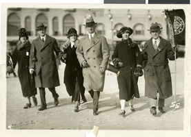
Photograph of Fleming and Ida Hubbard at J. C. Penney convention, Atlantic City, New Jersey, circa early 1900s
Date
1900 to 1939
Archival Collection
Description
Fleming Ballew Hubbard and Ida Mae Conklin Hubbard, far left, with others at a J. C. Penney convention on the boardwalk in Atlantic City, New Jersey.
Image

Photograph of the Lockheed 14 aircraft, July 1938
Date
1938-07
Archival Collection
Description
The black and white, skyline view of New York City with Lockheed 14 aircraft flying in the foreground. Typed onto script included with the image: "Howard Hughes plane Lockheed 14 in flight over lower New York City. To right in the background can be seen New York City's three bridges of the lower East River from front to rear: the Brooklyn Bridge, Manhattan Bridge, and the Williamsburg Bridge."
Image