Search Results
Start of New York-to-Paris Race, Times Square, New York City, February 12, 1908, reproduction courtesy Harrah's Automobile Collection: photographic print: photographic negative, 1964
Level of Description
Item
Archival Collection
Nan Doughty Photograph Collection
To request this item in person:
Collection Number: PH-00240
Collection Name: Nan Doughty Photograph Collection
Box/Folder: Folder 16
Collection Name: Nan Doughty Photograph Collection
Box/Folder: Folder 16
Archival Component
Lottery ticket from Honduras National Lottery Company in Louisiana; lottery ticket-beneficencia; New York state lottery advertisement; New York state Olympic lottery, 1904-1979
Level of Description
File
Archival Collection
UNLV University Libraries Collection on International Lotteries
To request this item in person:
Collection Number: MS-00619
Collection Name: UNLV University Libraries Collection on International Lotteries
Box/Folder: Oversized Box 01
Collection Name: UNLV University Libraries Collection on International Lotteries
Box/Folder: Oversized Box 01
Archival Component
Florman, Samuel C. Gee, This is Magnificent, New York Times Magazine, 1989 February 12
Level of Description
File
Archival Collection
UNLV Libraries Collection of Articles on Gaming and Las Vegas, Nevada Topics
To request this item in person:
Collection Number: MS-00626
Collection Name: UNLV Libraries Collection of Articles on Gaming and Las Vegas, Nevada Topics
Box/Folder: Box 15
Collection Name: UNLV Libraries Collection of Articles on Gaming and Las Vegas, Nevada Topics
Box/Folder: Box 15
Archival Component
Davies. J. B., and C. B. Archambeau, 1997, "Geohydrological models and earthquake effects at Yucca Mountain, Nevada," Environmental Geology, Volume 32. Number 1. pp. 23-35. New York, New York, 1997
Level of Description
File
Archival Collection
Environmental Radiation Protection Standards for Yucca Mountain, Nevada
To request this item in person:
Collection Number: MS-00603
Collection Name: Environmental Radiation Protection Standards for Yucca Mountain, Nevada
Box/Folder: Box 05
Collection Name: Environmental Radiation Protection Standards for Yucca Mountain, Nevada
Box/Folder: Box 05
Archival Component
Salk, M. S.; Tolbert, V.R.; and Dickerman, J.A. 1999. "Guidelines and Techniques for Improving the NEPA Process." Environmental Management. 23, (4). 467-476. New York, New York: Springer-Verlag, 1999
Level of Description
File
Archival Collection
Environmental Radiation Protection Standards for Yucca Mountain, Nevada
To request this item in person:
Collection Number: MS-00603
Collection Name: Environmental Radiation Protection Standards for Yucca Mountain, Nevada
Box/Folder: Box 44
Collection Name: Environmental Radiation Protection Standards for Yucca Mountain, Nevada
Box/Folder: Box 44
Archival Component
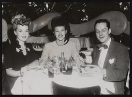
Photograph of Donn Arden at La Martinique, New York (N.Y.), 1940s-1950s
Date
1940 to 1959
Archival Collection
Description
Donn Arden (right) at La Martinique Nightclub with two unidentified women.
Image
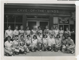
Photograph of the Las Vegas High School Rhythmettes, Niagara Falls, New York, July 24, 1955
Date
1955-07-24
Archival Collection
Description
A group of the Las Vegas High School Rhythmettes posing in front of the Cave-of-the-Winds in Niagara Falls, New York.
Image
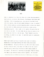
Biography of West written by Epic Records (New York), June 17-19, 1968
Date
1968-06
Archival Collection
Description
A biography of the musical group West, written by Epic Records (New York) and given to the Sands Hotel (Las Vegas), for the Epic Records National Sales Convention. The five-page biography lists all of the members in the group, and provides a small bio on each member; including information on how long they have been performing together and which instruments they play.
Mixed Content
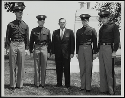
Howard Cannon visits West Point, New York with four unidentified cadets: photographic print
Date
1970-10-08
Archival Collection
Description
From the Howard Cannon Photograph Collection (PH-00192). Stamped on verso: "Signal Division File #USMA-64-1996 NR West Point New York 25 May 64 - Photo by Mr Murphy". Stamped on verso: "Please give credit as 'U.S. Army Photograph'"
Image
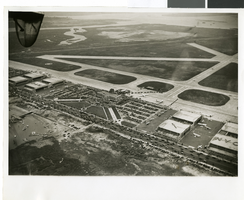
Photograph of the landing of Howard Hughes' Lockheed 14 aircraft, New York, July 14, 1938
Date
1938-07-14
Archival Collection
Description
The black and white, aerial view of Howard Hughes' Lockheed 14 aircraft performing its final landing on the Round the World flight at Floyd Bennett Airport, New York. Typed onto a piece of paper attached to the image: "Journey's End: This airplane view records the end of Howard Hughes' history-making dash around the world in three days, nineteen hours. To the right of the Administration Building at Floyd Bennett Field, Long Island, New York, can be seen the globe-girdling monoplane surrounded by a ring of policemen. The foreground provides an accurate idea of the size of the crowd which stormed the field to welcome home the fliers. Credit Line (ACME)."
Image