Search Results
Cumorah Credit Union, 1989 May 15; 1990 July 16
Level of Description
File
Archival Collection
Alton Dean Jensen Architectural Records
Archival Component
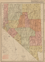
Rand-McNally new commercial atlas map of Nevada, 1912
Date
1912
Description
Original publisher: Rand, McNally & Co. Scale [ca. 1:1,203,840). 1 inch to 19 miles. Originally published as p. 316-317 of Rand McNally's commercial atlas of America. Title in right margin: Nevada : commercial atlas of America. Includes township and range grid. Includes index to Nevada railroads and index to principal cities with their populations. Index on verso to counties, towns and natural features in Oregon and Nevada.
Image

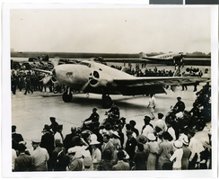
Photograph of the landing of Howard Hughes' Lockheed 14 aircraft, New York, July 14, 1938
Date
1938-07-14
Archival Collection
Description
The black and white view of Howard Hughes' Lockheed 14 aircraft performing its final landing on the Round the World flight at Floyd Bennett Airport, New York. Typed onto a piece of paper attached to the image: "Howard Hughes lands at Floyd Bennett Field. 7/38."
Image
Photograph of the landing of Howard Hughes' Lockheed 14 aircraft, New York, July 14, 1938
Date
1938-07-14
Archival Collection
Description
The black and white view of Howard Hughes' Lockheed 14 aircraft performing its final landing on the Round the World flight at Floyd Bennett Airport, New York. Typed onto a piece of paper attached to the image: "Howard Hughes taxiing up runway at Floyd Bennett Airport."
Image
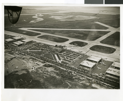
Photograph of the landing of Howard Hughes' Lockheed 14 aircraft, New York, July 14, 1938
Date
1938-07-14
Archival Collection
Description
The black and white, aerial view of Howard Hughes' Lockheed 14 aircraft performing its final landing on the Round the World flight at Floyd Bennett Airport, New York. Typed onto a piece of paper attached to the image: "Journey's End: This airplane view records the end of Howard Hughes' history-making dash around the world in three days, nineteen hours. To the right of the Administration Building at Floyd Bennett Field, Long Island, New York, can be seen the globe-girdling monoplane surrounded by a ring of policemen. The foreground provides an accurate idea of the size of the crowd which stormed the field to welcome home the fliers. Credit Line (ACME)."
Image
View of Buffet at party: photographic print and negative, 1951 July 15
Level of Description
File
Archival Collection
William J. Moore Jr. Photograph Collection
Archival Component
Remains of Princess Mill foundations: photographic print, 1972 July 15
Level of Description
Item
Archival Collection
Nan Doughty Photograph Collection
Archival Component
Northern Belle Hill and Candelaria: photographic print, 1972 July 15
Level of Description
Item
Archival Collection
Nan Doughty Photograph Collection
Archival Component
Woman posed in front of a house: photographic print, 1950 July 15
Level of Description
Item
Archival Collection
Hazel Baker Denton Photograph Collection
Archival Component
Martin family oral history interview summary, 2006 July 15
Level of Description
File
Archival Collection
Jarbidge, Nevada Community Archives Collection
Archival Component