Search Results
The New Fay Easter dinner menu, Sunday, April 7, 1912
Date
1912-04-07
Archival Collection
Description
Restaurant: The New Fay (Virginia, Minn.) Location: Virginia, Minnesota, United States
Text
Minority Recruiting in the New York City Police Department by the New York City Rand Institute, 1971 May
Level of Description
File
Archival Collection
Ardis Kearns Papers
To request this item in person:
Collection Number: MS-00348
Collection Name: Ardis Kearns Papers
Box/Folder: Box 18
Collection Name: Ardis Kearns Papers
Box/Folder: Box 18
Archival Component
The Police Internal Administration of Justice in New York City by the New York City Rand Institute, 1970 November
Level of Description
File
Archival Collection
Ardis Kearns Papers
To request this item in person:
Collection Number: MS-00348
Collection Name: Ardis Kearns Papers
Box/Folder: Box 19
Collection Name: Ardis Kearns Papers
Box/Folder: Box 19
Archival Component

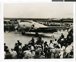
Photograph of the landing of Howard Hughes' Lockheed 14 aircraft, New York, July 14, 1938
Date
1938-07-14
Archival Collection
Description
The black and white view of Howard Hughes' Lockheed 14 aircraft performing its final landing on the Round the World flight at Floyd Bennett Airport, New York. Typed onto a piece of paper attached to the image: "Howard Hughes lands at Floyd Bennett Field. 7/38."
Image
Photograph of the landing of Howard Hughes' Lockheed 14 aircraft, New York, July 14, 1938
Date
1938-07-14
Archival Collection
Description
The black and white view of Howard Hughes' Lockheed 14 aircraft performing its final landing on the Round the World flight at Floyd Bennett Airport, New York. Typed onto a piece of paper attached to the image: "Howard Hughes taxiing up runway at Floyd Bennett Airport."
Image
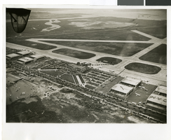
Photograph of the landing of Howard Hughes' Lockheed 14 aircraft, New York, July 14, 1938
Date
1938-07-14
Archival Collection
Description
The black and white, aerial view of Howard Hughes' Lockheed 14 aircraft performing its final landing on the Round the World flight at Floyd Bennett Airport, New York. Typed onto a piece of paper attached to the image: "Journey's End: This airplane view records the end of Howard Hughes' history-making dash around the world in three days, nineteen hours. To the right of the Administration Building at Floyd Bennett Field, Long Island, New York, can be seen the globe-girdling monoplane surrounded by a ring of policemen. The foreground provides an accurate idea of the size of the crowd which stormed the field to welcome home the fliers. Credit Line (ACME)."
Image

Photograph of Howard Hughes and others at Newark Airport, New Jersey, July 21, 1938
Date
1938-07-21
Archival Collection
Description
Typed onto a piece of paper attached to the image: "Howard Hughes in center leaves Newark Airport with party enroute to Washington, D.C. 7/21/38."
Image

Photograph of the landing of Howard Hughes' Lockheed 14 aircraft, New York, July 14, 1938
Date
1938-07-14
Archival Collection
Description
The black and white, aerial view of Howard Hughes' Lockheed 14 aircraft after performing its final landing on the Round the World flight at Floyd Bennett Airport, New York. Typed onto a piece of paper attached to the image: "Aerial view of Hughes reception at Floyd Bennett Field. 7/14/38 (Press Association)"
Image

Photograph of museum basement floor plan, Boulder City (Nev.), February 11, 1938
Date
1938-02-11
Archival Collection
Description
Boulder City Museum basement floor plan.
Image

Photograph of the landing of Howard Hughes' Lockheed 14 aircraft, New York, July 14, 1938
Date
1938-07-14
Archival Collection
Description
The black and white, aerial view of Howard Hughes' Lockheed 14 aircraft after performing its final landing on the Round the World flight at Floyd Bennett Airport, New York. Typed onto a piece of paper attached to the image: "Crowd greeting Howard Hughes and crew at floyd Bennett Airport after completing Round-the-World flight."
Image