Search Results
Coalition for Casino Gambling: plan for New York City, undated
Level of Description
File
Archival Collection
Eugene Martin Christiansen Papers
Archival Component
New York City Council news reports and correspondence, 1990
Level of Description
File
Archival Collection
Eugene Martin Christiansen Papers
Archival Component
New York City Pizza, menu, approximately 1961 to 1990
Level of Description
File
Archival Collection
UNLV University Libraries Menu Collection
Archival Component
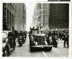
Photograph of Howard Hughes and his crew at a parade, New York, July 15, 1938
Date
1938-07-15
Archival Collection
Description
Description printed on photograph's accompanying sheet of paper: "Gen. view parade: As globe fliers braved Broadway blizzard, New York. Although they didn't encounter a single snowflake on their roaring dash across Siberia, Howard Hughes and his four-man crew met a regular blizzard (of Broadway ticker tape) today as New York paid them homage as only New York know how. This is a view of the scene as the triumphal procession proceeded from the Battery to City Call. In the car are (left to right) Grover Whalen, President of the New York World's Fair, Howard Hughes and Al Lodwick, his press representative. (w) 7-15-38.30."
Image
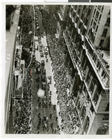
Photograph of Howard Hughes and his crew at a parade, New York, July 15, 1938
Date
1938-07-15
Archival Collection
Description
Typed onto a piece of paper attached to the image: "Howard Hughes and crew in parade up Broadway after record-breaking world flight. New York, New York."
Image
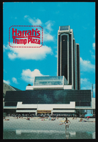
Harrah's at Trump Plaza in Atlantic City, New Jersey: postcard
Date
1940 (year approximate) to 1990 (year approximate)
Archival Collection
Description
From Harvey's Hotel and Casino Postcard Collection (PH-00367)
Image

Map of California, Utah, Nevada, Colorado, New Mexico and Arizona, circa 1867
Date
1865 to 1869
Description
39 x 56 cm. Relief shown by hachures. "Entered according to act of Congress in the year 1864, by A.J. Johnson in the Clerks Office of the United States for the Southern District of New York." Atlas page numbers in upper margin: 67-68. Primer meridians: Greenwich and Washington, D.C. On verso: History and statistical view of the West India islands or Columbian Archipelago and Historical and statistical view of Mexico and Central America. Shows proposed railroads, locations of Indian tribes, natural features, counties, mines, mail routes, trails and routes of exploring expeditions. Has decorative border. Southern part of Nevada was added to the state in 1867 and is part of Nevada on this map, but Lincoln County was established in 1867 and is not on this map. This map was still probably published in 1867 in spite of someone's having written "1864" in pencil in the lower right corner of the Library's copy. Original publisher: A.J. Johnson.
Image
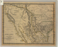
Map of Texas, California, New Mexico and the northern states of Mexico, October 15, 1842
Date
1842-10-15
Description
'Published under the superintendence of the Society for Diffusion of Useful Knowledge.' 'Published by Chapman & Hall, 186 Strand, 15 Oct. 1842.' 'J. & C. Walker, Sculpt.' Scale [ca. 1:7,600,000]. 1 in. to ca. 120 miles (W 125°--W 91°/N 43°--N 23° 30?). 1 map ; 31 x 39 cm. Relief indicated by hachures and spot heights. Shows elevations in yards. Includes notes on exploring expeditions, etc. Borders hand colored. Chapman & Hall.
Image
T-Shirt Color: Gray; Front: City Of New York Fire Dept. FDNY, Dept. Badge W/ New York City Sky Line, approximately 2001-2012
Level of Description
File
Archival Collection
New York-New York Hotel and Casino 9-11 Heroes Tribute Collection
Archival Component
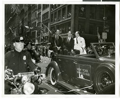
Photograph of Howard Hughes and his crew at a parade, New York, July 15, 1938
Date
1938-07-15
Archival Collection
Description
Description printed on back of photograph: "New York welcomes Howard Hughes. Grover Whalen also in car. 7/15/38."
Image