Search Results
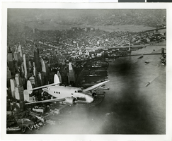
Photograph of the Lockheed 14 aircraft, July 1938
Date
1938-07
Archival Collection
Description
The black and white, skyline view of New York City with Lockheed 14 aircraft flying in the foreground. Typed onto script included with the image: "Howard Hughes plane Lockheed 14 in flight over lower New York City. To right in the background can be seen New York City's three bridges of the lower East River from front to rear: the Brooklyn Bridge, Manhattan Bridge, and the Williamsburg Bridge."
Image
Willapa Harbor and Florence, Oregon: photographic negative, approximately 1938 April to 1938 May
Level of Description
Item
Archival Collection
Nan Doughty Photograph Collection
To request this item in person:
Collection Number: PH-00240
Collection Name: Nan Doughty Photograph Collection
Box/Folder: Box SH-028
Collection Name: Nan Doughty Photograph Collection
Box/Folder: Box SH-028
Archival Component
Picture of unknown couple, 1938
Level of Description
File
Archival Collection
Walking Box Ranch Photograph Collection
To request this item in person:
Collection Number: PH-00346
Collection Name: Walking Box Ranch Photograph Collection
Box/Folder: N/A
Collection Name: Walking Box Ranch Photograph Collection
Box/Folder: N/A
Archival Component
Bills of lading, 1938 to 1940
Level of Description
File
Archival Collection
Tonopah and Tidewater Railroad Records
To request this item in person:
Collection Number: MS-00006
Collection Name: Tonopah and Tidewater Railroad Records
Box/Folder: Box 2
Collection Name: Tonopah and Tidewater Railroad Records
Box/Folder: Box 2
Archival Component
Newspaper clippings, 1936-1938
Level of Description
File
Archival Collection
Sherwin "Scoop" Garside Papers
To request this item in person:
Collection Number: MS-00342
Collection Name: Sherwin "Scoop" Garside Papers
Box/Folder: Box 06
Collection Name: Sherwin "Scoop" Garside Papers
Box/Folder: Box 06
Archival Component
Grabske-Gregory, 1938-1990
Level of Description
File
Archival Collection
Thomas P. O'Farrell Papers
To request this item in person:
Collection Number: MS-00639
Collection Name: Thomas P. O'Farrell Papers
Box/Folder: Box 27
Collection Name: Thomas P. O'Farrell Papers
Box/Folder: Box 27
Archival Component
Brody-Brown, 1938-1991
Level of Description
File
Archival Collection
Thomas P. O'Farrell Papers
To request this item in person:
Collection Number: MS-00639
Collection Name: Thomas P. O'Farrell Papers
Box/Folder: Box 20
Collection Name: Thomas P. O'Farrell Papers
Box/Folder: Box 20
Archival Component
Cottam-Custer, 1938-1989
Level of Description
File
Archival Collection
Thomas P. O'Farrell Papers
To request this item in person:
Collection Number: MS-00639
Collection Name: Thomas P. O'Farrell Papers
Box/Folder: Box 23
Collection Name: Thomas P. O'Farrell Papers
Box/Folder: Box 23
Archival Component
Mashburn, Gray: ephemera, 1938
Level of Description
File
Archival Collection
UNLV Libraries Collection of Biographical Files
To request this item in person:
Collection Number: MS-01049
Collection Name: UNLV Libraries Collection of Biographical Files
Box/Folder: Box 05
Collection Name: UNLV Libraries Collection of Biographical Files
Box/Folder: Box 05
Archival Component
Interior view of the study, 1938
Level of Description
File
Archival Collection
Robert Worts Photographs
To request this item in person:
Collection Number: PH-00007
Collection Name: Robert Worts Photographs
Box/Folder: Folder 01
Collection Name: Robert Worts Photographs
Box/Folder: Folder 01
Archival Component