Search Results
Crowd standing outside City Hall while Howard Hughes and his crew get their picture taken in celebration of Hughes's completion of his around-the-world flight in New York City, 1938 July 15
Level of Description
File
Archival Collection
Howard Hughes Public Relations Photograph Collection
Archival Component
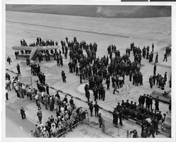
Photograph of a crowd awaiting the arrival of Howard Hughes' plane at Floyd Bennett Airport, New York, July 14, 1938
Date
1938-07-14
Archival Collection
Description
The black and white view of a crowd of people awaiting the arrival Lockheed 14 aircraft at Floyd Bennett Airport in New York. Typed onto a piece of paper attached to the image: "Tumultuous welcome awaits world fliers here Floyd Bennett Airport, N.Y. -- Policemen lined up on the field here awaiting the arrival of Howard Hughes and his companions, New York bound from Minneapolis, on the last leg of their epochal Round-The-World flight. By noon, a crowd of 6,000 persons had gathered at the airport, and it was increasing by the moment. Credit line (ACME). 7/14/38."
Image
New faculty members on August 15, 2013: digital photographs
Date
2013-08-15
Archival Collection
Description
Photographs from the University of Nevada, Las Vegas Creative Services Records (2010s) (PH-00388-05). Client: Kristene Fisher, Vice Provost for Academic Affairs
Image
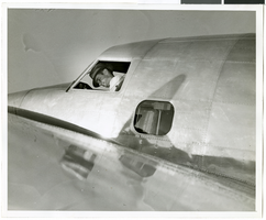
Photograph of Howard Hughes in his Lockheed 14 aircraft, Floyd Bennett Field, New York, July 10, 1938
Date
1938-07-10
Archival Collection
Description
The black and white view of Howard Hughes in his Lockheed 14 aircraft at Floyd Bennett Field in New York. Text printed on accompanying paper strip: "Hughes takes off on flight to Paris. Floyd Bennett Field, New York City-- Howard Hughes, multi-millionaire speed flyer, pictured in the nose of his Hughes Lockheed "Flying Laboratory" as Hughes and his picked crew of four prepared for the take-off to Paris and probably around the world on July 10th. A few minutes after this picture was taken, the giant ship lifted from the field to follow the trail blazed by Chrales A. Lindbergh. Credit Line (ACME) 7/10/38."
Image

Map of California, Nevada, Utah, Colorado, Arizona & New Mexico, circa 1867
Date
1865 to 1869
Description
39 x 62 cm. Relief shown by hachures and spot heights. Prime meridian: Greenwich and Washington. Hand colored. Shows natural features, populated places, routes of mail steamships, routes of explorers, locations of Indian tribes, railroad routes, and proposed railroad routes. In top margin: No. 80-81. On verso: New Mexico, Arizona, Colorado, Idaho, Dakota (statistics and other information) and The state of California (statistics and other information). Original publisher: G.W. and C.B. Colton.
Image

Map of California, and territories of Utah, Nevada, Colorado, New Mexico and Arizona, 1864
Date
1864
Description
'Johnson's California, also Utah, Nevada, Colorado, New Mexico, and Arizona, published by A.J. Johnson, New York.' 'Entered according to act of Congress in the year 1864, by A.J. Johnson in the Clerks Office of the District Court of the United States for the southern district of New York.' Atlas page numbers in upper margin: 67-68. Relief shown by hachures. Prime meridian: Greenwich and Washington. Shows natural features, locations of Indian tribes, proposed railroad routes, routes of explorers, trails, county boundaries and populated places. Hand colored. On verso: 'Historical and statistical view of the West India Islands or Columbian Archipelago' (p. 80) and 'Historical and statistical view of Mexico and Central America' (p. 79). Scale [ca. 1:3,484,800]. 1 in. to ca. 55 miles (W 124°--W 102°/N 42°--N 32°).
Text
Etna, Lincoln County, Nevada, circa 1938, 1938
Level of Description
File
Archival Collection
Elbert Edwards Photograph Collection
Archival Component