Search Results
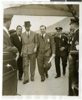
Photograph of Howard Hughes and Grover Whalen at Floyd Bennett Field, New York, July 10, 1938
Date
1938-07-10
Archival Collection
Description
The black and white view of Howard Hughes and Grover Whalen at Floyd Bennett Airport just before Hughes takes off for Paris.
Image
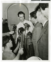
Photograph of Howard Hughes and Grover Whalen at Floyd Bennett Airfield, New York, July 14, 1938
Date
1938-07-14
Archival Collection
Description
A view of Howard Hughes being escorted by Grover Whalen and several guards at Floyd Bennett Airfield.
Image
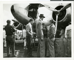
Photograph of Howard Hughes and the Lockheed 14 aircraft, Fairbanks, Alaska, July 15, 1938
Date
1938-07-15
Archival Collection
Description
The black and white view of Howard Hughes standing with several unidentified men near the Lockheed 14 aircraft that was then being refueled. Hughes was then on his Around the World Flight where he visited Paris, Moscow, Fairbanks, and Alaska.
Image
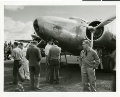
Photograph of Howard Hughes and the Lockheed 14 aircraft, Fairbanks, Alaska, July 15, 1938
Date
1938-07-15
Archival Collection
Description
The black and white view of Howard Hughes standing with several unidentified men near the Lockheed 14 aircraft that was then being refueled. Hughes was then on his Around the World Flight where he visited Paris, Moscow, Fairbanks, and Alaska.
Image

Photograph of Howard Hughes in cockpit, New York, February 15, 1946
Date
1946-02-15
Archival Collection
Description
A view of Howard Hughes, left, and other men who helped to pilot a Trans World Airline aircraft in New York.
Image
"Yankee Baseball Greats 1938" photograph, 1938
Level of Description
File
Archival Collection
Nat Hart Professional Papers
To request this item in person:
Collection Number: MS-00419
Collection Name: Nat Hart Professional Papers
Box/Folder: Box 16 (Restrictions apply)
Collection Name: Nat Hart Professional Papers
Box/Folder: Box 16 (Restrictions apply)
Archival Component

Map of California, Nevada, Utah, Colorado, Arizona & New Mexico, circa 1867
Date
1865 to 1869
Description
39 x 62 cm. Relief shown by hachures and spot heights. Prime meridian: Greenwich and Washington. Hand colored. Shows natural features, populated places, routes of mail steamships, routes of explorers, locations of Indian tribes, railroad routes, and proposed railroad routes. In top margin: No. 80-81. On verso: New Mexico, Arizona, Colorado, Idaho, Dakota (statistics and other information) and The state of California (statistics and other information). Original publisher: G.W. and C.B. Colton.
Image
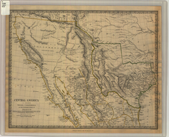
Map of Texas, California, New Mexico and the northern states of Mexico, October 15, 1842
Date
1842-10-15
Description
'Published under the superintendence of the Society for Diffusion of Useful Knowledge.' 'Published by Chapman & Hall, 186 Strand, 15 Oct. 1842.' 'J. & C. Walker, Sculpt.' Scale [ca. 1:7,600,000]. 1 in. to ca. 120 miles (W 125°--W 91°/N 43°--N 23° 30?). 1 map ; 31 x 39 cm. Relief indicated by hachures and spot heights. Shows elevations in yards. Includes notes on exploring expeditions, etc. Borders hand colored. Chapman & Hall.
Image

Map of California, and territories of Utah, Nevada, Colorado, New Mexico and Arizona, 1864
Date
1864
Description
'Johnson's California, also Utah, Nevada, Colorado, New Mexico, and Arizona, published by A.J. Johnson, New York.' 'Entered according to act of Congress in the year 1864, by A.J. Johnson in the Clerks Office of the District Court of the United States for the southern district of New York.' Atlas page numbers in upper margin: 67-68. Relief shown by hachures. Prime meridian: Greenwich and Washington. Shows natural features, locations of Indian tribes, proposed railroad routes, routes of explorers, trails, county boundaries and populated places. Hand colored. On verso: 'Historical and statistical view of the West India Islands or Columbian Archipelago' (p. 80) and 'Historical and statistical view of Mexico and Central America' (p. 79). Scale [ca. 1:3,484,800]. 1 in. to ca. 55 miles (W 124°--W 102°/N 42°--N 32°).
Text
Adamar of New Jersey License Application, December 15, 1981
Level of Description
File
Archival Collection
International Association of Gaming Attorneys Collection
To request this item in person:
Collection Number: MS-00250
Collection Name: International Association of Gaming Attorneys Collection
Box/Folder: Box 01
Collection Name: International Association of Gaming Attorneys Collection
Box/Folder: Box 01
Archival Component