Search Results
Las Vegas Valley Water District: "Comprehensive Annual Financial Report for the Fiscal Year Ended June 30, 2004", 2004 October 05
Level of Description
File
Archival Collection
Bruce Turner Collection on Transportation and Water in Southern Nevada
To request this item in person:
Collection Number: MS-00648
Collection Name: Bruce Turner Collection on Transportation and Water in Southern Nevada
Box/Folder: Box 12
Collection Name: Bruce Turner Collection on Transportation and Water in Southern Nevada
Box/Folder: Box 12
Archival Component
Las Vegas Valley Water District: "Comprehensive Annual Financial Report for the Fiscal Year Ended June 30, 2003", 2003 October 17
Level of Description
File
Archival Collection
Bruce Turner Collection on Transportation and Water in Southern Nevada
To request this item in person:
Collection Number: MS-00648
Collection Name: Bruce Turner Collection on Transportation and Water in Southern Nevada
Box/Folder: Box 12
Collection Name: Bruce Turner Collection on Transportation and Water in Southern Nevada
Box/Folder: Box 12
Archival Component
Las Vegas Valley Water District: "Comprehensive Annual Financial Report for the Fiscal Year Ended June 30, 2002", 2002 November 15
Level of Description
File
Archival Collection
Bruce Turner Collection on Transportation and Water in Southern Nevada
To request this item in person:
Collection Number: MS-00648
Collection Name: Bruce Turner Collection on Transportation and Water in Southern Nevada
Box/Folder: Box 12
Collection Name: Bruce Turner Collection on Transportation and Water in Southern Nevada
Box/Folder: Box 12
Archival Component
Campus life at 50 years photograph album, HRL scrapbook, 1995 Earth Day plaque from RHA students, approximately 1995 to 2018
Level of Description
File
Archival Collection
University of Nevada, Las Vegas Housing and Residential Life Records
To request this item in person:
Collection Number: UA-00105
Collection Name: University of Nevada, Las Vegas Housing and Residential Life Records
Box/Folder: Oversized Box 05
Collection Name: University of Nevada, Las Vegas Housing and Residential Life Records
Box/Folder: Oversized Box 05
Archival Component

Topographic map of Nevada-California, Las Vegas quadrangle, March 1908
Date
1908-03
Description
'Edition of Mar. 1908.' 'E.M. Douglas, geographer in charge; Topography and triangulation by R.H. Chapman, B.D. Stewart, J.E. Blackburn, and D.F.C. Moor. Surveyed in 1906-1907.' Scale 1:250,000 (W 116°00--W 115°00/N 37°00--N 36°00). Relief shown by contours and spot heights. Title in lower-right corner: Las Vegas. Contour interval 100 feet. Datum is mean sea level. "Topography"--Center of top margin. Text about the Topographic Maps of the United States series and symbols used on map on verso. U.S. Geological Survey
Text

Street map of greater Las Vegas, Nevada, 1965-1966
Date
1965 to 1966
Description
Rev. 1965-1966 ed. 55 x 42 cm., folded to 29 x 12 cm. Panel title: Front Boy's official street map. Relief shown by spot heights. Copyright held by Russell A. Meador. Includes notes, quotations and indexes. Street index on verso. "Detailed guide of North Las Vegas, Las Vegas, Paradise Valley, and vicinity." Original publisher: Meador, Russell A.
Image
Moore, Wilisha C., "Workforce Diversity Programs: A Case Study of the Las Vegas Valley Water District's "3-year Diversity Implementation Plan"", 2002 Spring
Level of Description
Item
Archival Collection
University of Nevada, Las Vegas Theses, Dissertations, and Honors Papers
To request this item in person:
Collection Number: UA-00082
Collection Name: University of Nevada, Las Vegas Theses, Dissertations, and Honors Papers
Box/Folder: Box 358
Collection Name: University of Nevada, Las Vegas Theses, Dissertations, and Honors Papers
Box/Folder: Box 358
Archival Component

Geology of the Jackass Flats quadrangle, Nye County, Nevada, 1964
Date
1964
Description
58 x 47 cm., on sheet 86 x 81 cm., folded in envelope 30 x 24 cm. Relief shown by contours and spot heights. "Geology mapped in 1961." Includes description of map units, 2 col. cross sections, and quadrangle location map. "Prepared in cooperation with the U. S. Atomic Commission." Original publisher: Interior, Geological Survey, Series: Geologic quadrangle map GQ, Scale: 1:24 000.
Image
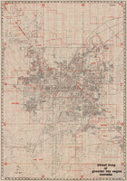
Street map of greater Las Vegas, Nevada, 1984
Date
1984
Description
'The professional street map of greater Las Vegas, Nevada. Detailed guide of Las Vegas, North Las Vegas, Paradise Valley & vicinity' -- front panel. ' Street index on map verso. Original publisher: Front Boy Service Co. Scale [ca. 1:44,352. 1 in. to approx. 0.70 mi.].
Text