Search Results
Nevada Poetry Society Records
Identifier
Abstract
The Nevada Poetry Society Records are comprised of the Society's records dating from 1961 to 1973. Society organizer and president, Mildred Breedlove is featured prominently in the collection. Materials include Silver Strings: Nevada Poetry Society Anthology, a collection of poems commemorating Nevada's centennial year, individual poems from members, financial records, correspondence, and newsletters.
Archival Collection
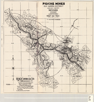
Map of Pioche mines, Ely Mining District, Lincoln County, Nevada, 1909
Date
Description
Image
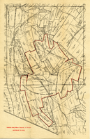
Map of mines owned and operated by Goldfield Deep Mines Company of Nevada, circa 1904-1908
Date
Description
Image

Original plat, townsite of Las Vegas, Lincoln Co., Nevada, January 13, 1905
Date
Description
Subtitle: 'Embracing the N. 1/2 of S.W. 1/4 Sec. 27 Township 20S. R.61E. Mt. Diablo Meridian.' 'Book 1, page 17A" handwritten in lower right corner. Signed by Henry Lee, County Recorder, Lincoln County Nevada. 'Filed at request of J.T. Williams, January 13th A.D. 1905.' Backwards handwriting on right side. Map has a Lincoln County seal on the bottom near the center. In the dedication J.T. McWilliams states that he has surveyed and platted the townsite of Las Vegas subject to the right of way of the San Pedro, Los Angeles and Salt Lake Railroad Company. He signed the dedication on Jan. 13, 1905, and it was signed by witnesses Scale [ca. 1:2,520? 1 inch to approx. 210 feet?]. Copy of a blueline print.
Image

Topographic map of Cane Spring, Nevada quadrangle, 1961
Date
Description
For sale by the U.S. Geological Survey
Image

Map of Argentite Red Mountain Mining District, Esmeralda County, Nevada, circa 1908-1913
Date
Description
Image
Freeze, G. 2001. "EIS Post-10,000 Year FEP's," Electronic correspondence log from G. Freeze to D. Lester (Jason Technologies), with attachments, 2001 September 10
Level of Description
Archival Collection
Collection Name: Environmental Radiation Protection Standards for Yucca Mountain, Nevada
Box/Folder: Box 38
Archival Component

Map of Las Vegas and vicinity, Nevada, circa 1957-1961
Date
Description
70 x 68 cm. on sheet 106 x 71 cm. Includes indexes. Includes Nellis Air Force Base, Henderson, and inset maps of Boulder City, Nevada, and Las Vegas's geographical location in the Southwest. "H-654-32" on the lower right-hand corner. Page 2 contains a photograph of the Fremont Street in Downtown Las Vegas, featuring the Golden Nugget Gambling Hall and the Horseshoe Casino. Page 3 outlines local and regional attractions, as well as population information. Original publisher: R. L. Polk.
Image