Search Results
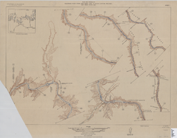
Map of plan and profile of Colorado River from Lees Ferry, Arizona to Black Canyon, Arizona-Nevada and Virgin River, Nevada, 1924
Date
1924
Archival Collection
Description
1 map in 21 sheets (14 plans, 7 profiles): col. ; 46 x 64 cm. Notes Relief shown by contours. Each sheet includes a key map. Surveys for individual sheets conducted 1919-23. Library has: Sheets I (2 copies), J, K, L, M, and N only. "Contour interval on land 50 feet." "Contour interval on river surface 5 feet." "Datum is mean sea level." "Mileage is measured from U. S. G. S. concrete gauge well opposite mouth of Paria River." "Topography by U. S. Reclamation Service." "Surveyed in 1919-23." Original publisher: U.S. Geological Survey, Scale: 1: 81,680.
Image
#70510: UNLV Alumna of the Year Kris Engelstad McGarry poses in her Engelstad Family Foundation office October 1, 2015 in Las Vegas., 2015 October 01
Level of Description
File
Archival Collection
University of Nevada, Las Vegas Creative Services Records (2010s)
To request this item in person:
Collection Number: PH-00388-05
Collection Name: University of Nevada, Las Vegas Creative Services Records (2010s)
Box/Folder: Digital File 00
Collection Name: University of Nevada, Las Vegas Creative Services Records (2010s)
Box/Folder: Digital File 00
Archival Component
#70396: Danielle Kelly, Executive Director of the Neon Musuem and College of Fine Arts Alumni of the Year award winner on August 17, 2015., 2015 August 17
Level of Description
File
Archival Collection
University of Nevada, Las Vegas Creative Services Records (2010s)
To request this item in person:
Collection Number: PH-00388-05
Collection Name: University of Nevada, Las Vegas Creative Services Records (2010s)
Box/Folder: Digital File 00
Collection Name: University of Nevada, Las Vegas Creative Services Records (2010s)
Box/Folder: Digital File 00
Archival Component
#70407: UNLV Boyd School of Law Alum of the Year Judge Linda Marquis poses at the Regional Justice Facility August 19, 2015., 2015 August 19
Level of Description
File
Archival Collection
University of Nevada, Las Vegas Creative Services Records (2010s)
To request this item in person:
Collection Number: PH-00388-05
Collection Name: University of Nevada, Las Vegas Creative Services Records (2010s)
Box/Folder: Digital File 00
Collection Name: University of Nevada, Las Vegas Creative Services Records (2010s)
Box/Folder: Digital File 00
Archival Component
Nevada Secretary of State Records
Identifier
MS-00704
Abstract
The Nevada Secretary of State Records contain biennial reports for the years 1877-1892, 1897-1904, 1909-1910, 1919-1920,1940-1942, and 1947-1974. Material includes notary appointments and official records of the acts of the Nevada Legislature.
Archival Collection
Regional Transportation Commission of Southern Nevada: "Las Vegas Resort Corridor Fixed Guideway Downtown Extension (Robert N. Broadbent Las Vegas Monorail Downtown Extension), Section 5309 New Starts Criteria Submittal for Fiscal Year 2006", 2004 August 17
Level of Description
File
Archival Collection
Bruce Turner Collection on Transportation and Water in Southern Nevada
To request this item in person:
Collection Number: MS-00648
Collection Name: Bruce Turner Collection on Transportation and Water in Southern Nevada
Box/Folder: Box 25
Collection Name: Bruce Turner Collection on Transportation and Water in Southern Nevada
Box/Folder: Box 25
Archival Component
Rex Larbow Tom Bell, age 3 years old, riding on a hobby horse, and wearing cowboy outfit (horse was given to him by Tom Mix), 1930 to 1945
Level of Description
File
Archival Collection
Walking Box Ranch Photograph Collection
To request this item in person:
Collection Number: PH-00346
Collection Name: Walking Box Ranch Photograph Collection
Box/Folder: N/A
Collection Name: Walking Box Ranch Photograph Collection
Box/Folder: N/A
Archival Component
Berkowitz, Edward D. and Mark J. Santangelo. The Medical Follow-up Agency: The First 50 Years, 1947 through 1996. Washington, D.C.: National Academy Press, 1999
Level of Description
Item
Archival Collection
Alice P. Broudy Papers on Broudy v. United States
To request this item in person:
Collection Number: MS-00097
Collection Name: Alice P. Broudy Papers on Broudy v. United States
Box/Folder: Box 10
Collection Name: Alice P. Broudy Papers on Broudy v. United States
Box/Folder: Box 10
Archival Component
Drama Festival 2001 t-shirt: Lori and the other Clark County high school drama teachers participated in developing and executing a festival for the students each year, 2001
Level of Description
File
Archival Collection
Lori Lipman Brown Papers
To request this item in person:
Collection Number: MS-00346
Collection Name: Lori Lipman Brown Papers
Box/Folder: Box 06
Collection Name: Lori Lipman Brown Papers
Box/Folder: Box 06
Archival Component
Mississippi: MS Tax Commission Gaming Regulations report; and applications for gaming license, key employee license, and two year gaming license renewal, 1993-1995
Level of Description
File
Archival Collection
Gary W. Royer Collection on Gaming
To request this item in person:
Collection Number: MS-00658
Collection Name: Gary W. Royer Collection on Gaming
Box/Folder: Box 003
Collection Name: Gary W. Royer Collection on Gaming
Box/Folder: Box 003
Archival Component