Search Results

Geologic map of the Trail Ridge quadrangle, Nye County, Nevada, 1968
Date
1968
Description
58 x 46 cm., on sheet 79 x 91 cm., folded in envelope 30 x 24 cm. Relief shown by contours and spot heights. "Prepared in cooperation with the U.S. Atomic Energy Commission." "Base by U.S. Geological Survey, 1962." "Geology mapped in 1963." "Contour interval 20 feet." Includes text, 2 col. cross sections, quadrangle location map, and 1 index map. Original publisher: Interior, Geological Survey, Series: Geologic quadrangle map GQ, Scale: 1:24 000.
Image
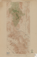
Topographic map of Goodsprings quadrangle, Nevada and California, 1919
Date
1919
Description
'R.B. Marshall, Chief Geographer; Geo. R. Davis, Geographer in charge; Topography by N.E. Ballmer and Roscoe Reeves; Control by J.E. Blackburn and L.F. Biggs. Surveyed in 1915-1916.' 'Edition of 1919.' Relief shown by hachures and spot heights. Title in lower right margin: Goodsprings. In center of top margin: Topography. Includes compilation diagram. Indicates location and density of cedar trees. Shows small portion of San Bernardino County, California. Published by U.S. Geological Survey. Scale 1:62,500 (W 115°35'00"--W 115°24'00"/N 36°02'30"--N 35°42'30"). 'Contour interval 50 feet. Datum is mean sea level.'
Text


Las Vegas Valley Water District: "Comprehensive Annual Financial Report for Fiscal Year Ended June 30, 2008", 2008 November 18
Level of Description
File
Archival Collection
Bruce Turner Collection on Transportation and Water in Southern Nevada
To request this item in person:
Collection Number: MS-00648
Collection Name: Bruce Turner Collection on Transportation and Water in Southern Nevada
Box/Folder: Box 12
Collection Name: Bruce Turner Collection on Transportation and Water in Southern Nevada
Box/Folder: Box 12
Archival Component
Las Vegas Valley Water District: "Comprehensive Annual Financial Report for the Fiscal Year Ended June 30, 1999", 1999 November 05
Level of Description
File
Archival Collection
Bruce Turner Collection on Transportation and Water in Southern Nevada
To request this item in person:
Collection Number: MS-00648
Collection Name: Bruce Turner Collection on Transportation and Water in Southern Nevada
Box/Folder: Box 12
Collection Name: Bruce Turner Collection on Transportation and Water in Southern Nevada
Box/Folder: Box 12
Archival Component
Las Vegas Valley Water District: "Comprehensive Annual Financial Report for the Fiscal Year Ended June 30, 2004", 2004 October 05
Level of Description
File
Archival Collection
Bruce Turner Collection on Transportation and Water in Southern Nevada
To request this item in person:
Collection Number: MS-00648
Collection Name: Bruce Turner Collection on Transportation and Water in Southern Nevada
Box/Folder: Box 12
Collection Name: Bruce Turner Collection on Transportation and Water in Southern Nevada
Box/Folder: Box 12
Archival Component