
Search the Special Collections and Archives Portal

Search Results

Display    Results Per Page
Displaying results 1591 - 1600 of 577637

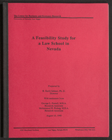
A Feasibility Study for a Law School in Nevada (bound)

Date

1990-08-15

Description

A bound version of "A Feasibility Study for a Law School in Nevada" prepared by R. Keith Schwer, Ph. D., Director, with assistance from George L. Fussell, M.B.A., Research Associate, and Mohammed H. Risheg, M.B.A., Research Associate, The Center for Business and Economic Research, University of Nevada, Las Vegas. From the University of Nevada, Las Vegas William S. Boyd School of Law Records (UA-00048).

Text

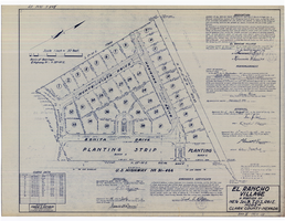
Plat map of El Rancho Village, Clark County, Nevada, July 28, 1942

Date

1942-07-28

Description

Map of housing subdivision outside the Las Vegas city limits. 'Approved this 28 day of July1942, by the City Planning Commission of the City of Las Vegas, County of Clark, Nevada. Approved this 28 day of July 1942, by the County Planning Commission of the County of Clark, State of Nevada.' Blueline print. Oriented with north to the upper right. Embossed with Engineering Certificate seal of Frank D. Rathburn, which states. 'Survey completed August 4, 1942.' 'Book II, page 53' hand printed in lower right corner. Signed by Clark County, Nevada Notary Public and other coumty officials and officials of El Rancho Village. Published by Office of F.D. Rathbun. Scale [ca. 1:600]. 1 inch to 50 feet

Text

Map of Las Vegas Rancho, Lincoln County, Nevada, September 15, 1904

Date

1904-09-15

Description

'Being part of Township 20 S. R.61 E. MT. D. B.&.M, containing 1864.49 acres. Division engineer's office at the front, AMB, September 15th, 1904. A.L. Jones, Division Engineer. Surveyed by W.G. Watson, Assistant Engineer. Dwg. 30296.' Includes traverse table. Shows land owned by the San Pedro, Los Angeles & Salt Lake Railroad, its right of way and the right of way for the Las Vegas & Tonopah Railroad, land owned by the Las Vegas Land & Water Company including Clark's Las Vegas Townsite with the Bucks Addition and the Wardie Addition, and parcels sold from the Las Vegas Land & Water Company land. Scale: [1:9,600]. 1 in. to 800 feet. Library's copies 1 and 4 have land owned by the San Pedro, Los Angeles & Salt Lake Railroad hand-colored in pink and the rest of the Las Vegas Rancho not owned by the Las Vegas Land & Water Company hand-colored in green. Library's copy 2 has buildings of the Stewart Ranch drawn in and labeled in pencil. Library's copy 3 has addition and subtraction problems in pencil on the verso. Library's copy 4 has "Original purchase--1864.49 acres R.R.C. + L.V.L. + W. Co.--In colors." written in pencil on the verso followed by "(1904)" in red pencil. Library's copy 4 also has label on verson made of brown paper with "No 5 Las Vegas Ranch being part township ( 1904)" typed on it.

Image

Geologic map of the Plutonium Valley quadrangle, Nye and Lincoln counties, Nevada, 1965

Date

1965

Description

58 x 46 cm., on sheet 77 x 83 cm., folded in envelope 30 x 24 cm. Relief shown by contours and spot heights. "Geology mapped in 1961." Includes description of map units, col. cross section, and quadrangle location map. "Prepared in cooperation with the U. S. Atomic Commission." Original publisher: Interior, Geological Survey, Series: Geologic quadrangle map GQ, Scale: 1:24 000.

Image

Nevada Secretary of State Records

Identifier

MS-00704

Abstract

The Nevada Secretary of State Records contain biennial reports for the years 1877-1892, 1897-1904, 1909-1910, 1919-1920,1940-1942, and 1947-1974. Material includes notary appointments and official records of the acts of the Nevada Legislature.

Archival Collection

Map showing location of the Las Vegas & Tonopah Railroad from Las Vegas to Bullfrog, Nevada, 1906

Date

1906

Description

'Office of Chief Engineer' printed on map above date.

Image

Freeze, G. 2001. "EIS Post-10,000 Year FEP's," Electronic correspondence log from G. Freeze to D. Lester (Jason Technologies), with attachments, 2001 September 10

Level of Description

File

Archival Collection

Environmental Radiation Protection Standards for Yucca Mountain, Nevada
To request this item in person:
Collection Number: MS-00603
Collection Name: Environmental Radiation Protection Standards for Yucca Mountain, Nevada
Box/Folder: Box 38

Archival Component

Las Vegas Valley map, Clark County, Nevada, June 1958

Date

1958

Description

'Compiled 1954. First revision - June 1958.' 'Area extends 9 miles north, 11 miles south, and 3 miles east, 3 miles west city limits of Las Vegas.' Original publisher: Campbell Realty. Scale [ca. 1:60,000. 1 in. to approx. 5,000 ft.]. Cadastral map. Hand-drawn red line around some sections on map.

Image