Search Results
New York: Volberg, Rachel A., "Gambling and Problem Gambling in New York: A 10-Year Replication Survey, 1986 to 1996" report, 1996 July
Level of Description
File
Archival Collection
Katherine A. Spilde Papers on Native American Gaming
To request this item in person:
Collection Number: MS-00092
Collection Name: Katherine A. Spilde Papers on Native American Gaming
Box/Folder: Box 15
Collection Name: Katherine A. Spilde Papers on Native American Gaming
Box/Folder: Box 15
Archival Component
Component Unit Annual Financial Report - Year End June 30, 1992 by Las Vegas Valley Water District, 1992 June 30
Level of Description
File
Archival Collection
Clark County Planning Commission Research Library Collection
To request this item in person:
Collection Number: MS-01027
Collection Name: Clark County Planning Commission Research Library Collection
Box/Folder: Box 79
Collection Name: Clark County Planning Commission Research Library Collection
Box/Folder: Box 79
Archival Component
S.1232 Moss: Policy on Regulation of Fish and Wildlife States) this year vs. S.2951. Contains correspondence and press release, 1969 July to 1970 January
Level of Description
File
Archival Collection
Howard Cannon Papers
To request this item in person:
Collection Number: MS-00002
Collection Name: Howard Cannon Papers
Box/Folder: Box 07 (92nd Session)
Collection Name: Howard Cannon Papers
Box/Folder: Box 07 (92nd Session)
Archival Component

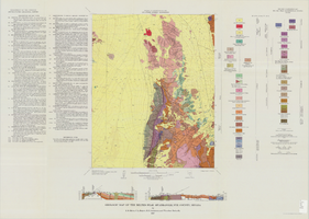
Geologic map of the Lathrop Wells quadrangle, Nye County, Nevada, 1970
Date
1970
Description
58 x 47 cm., on sheet 74 x 84 cm., folded in envelope 30 x 24 cm. Relief shown by contours and spot heights. "Bedrock geology mapped by B.C. Burchfiel, 1961, and by E.J. McKay and K.A. Sargent, 1965-66. Surficial geology mapped by A.T. Fernald, 1968." Includes cross sections, description of map units, and location map. "Prepared in cooperation with the U. S. Atomic Commission." Original publisher: Interior, Geological Survey, Series: Geologic quadrangle map GQ, Scale: 1:24 000.
Image

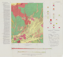
Geologic map of the Topopah Spring quadrangle, Nye County, Nevada, 1970
Date
1970
Description
58 x 46 cm., on sheet 84 x 88 cm., folded in envelope 30 x 24 cm. Relief shown by contours and spot heights. "Geology mapped in 1962-63." Includes description of map units, colored columnar section, 3 colored cross sections, and quadrangle location map. "Prepared in cooperation with the U. S. Atomic Commission." Original publisher: Interior, Geological Survey, Series: Geologic quadrangle map GQ, Scale: 1:24 000.
Image

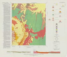
Geologic map of the Tippipah Spring quadrangle, Nye County, Nevada, 1963
Date
1963
Description
58 x 46 cm., on sheet 84 x 81 cm., folded in envelope 30 x 24 cm. Relief shown by contours and spot heights. "Geology by P.P. Orkild, 1959-60, paleotopography by D.L. Healey and C.H. Miller, 1959-60." Series statement from envelope. Includes description of map units, 2 col. cross sections, and quadrangle location map. "Prepared in cooperation with the U. S. Atomic Commission." Original publisher: Interior, Geological Survey, Series: Geologic quadrangle map GQ, Scale: 1:24 000.
Image

Geologic map of the Ammonia Tanks quadrangle, Nye County, Nevada, 1967
Date
1967
Description
58 x 46 cm., on sheet 84 x 100 cm., folded in envelope 30 x 24 cm. Relief shown by contours and spot heights. "Base by U.S. Geological Survey, 1961." "Geology mapped in 1961-65." "Contour interval 20 feet." Includes 3 col. cross sections, 1 index map, text with bibliography, and quadrangle location map. "Prepared in cooperation with the U. S. Atomic Commission." Original publisher: Interior, Geological Survey, Series: Geologic quadrangle map GQ, Scale: 1:24 000.
Image
Geologic map of the Belted Peak quadrangle, Nye County, Nevada, 1967
Date
1967
Description
45 x 36 cm., on sheet 64 x 89 cm., fold. in envelope 30 x 24 cm. Relief shown by contours and spot heights. "Contour interval 40 feet." "Prepared in cooperation with the U.S. Atomic Energy Commission." "Geology mapped in 1962-63." Includes text, 2 col. cross sections, and quadrangle location map. Original publisher: U.S. Geological Survey, Series: Geologic quadrangle map GQ, Scale: 1:62 500.
Image
Geologic map of the Thirsty Canyon quadrangle, Nye County, Nevada, 1966
Date
1966
Description
57 x 46 cm., on sheet 83 x 91 cm., folded in envelope 30 x 24 cm. Relief shown by contours and spot heights. "Geology mapped in 1963." Includes 2 colored cross sections, index map, text, and quadrangle location map. "Prepared in cooperation with the U. S. Atomic Commission." Original publisher: Interior, Geological Survey, Series: Geologic quadrangle map GQ, Scale: 1:24 000.
Image
Geologic map of the Trail Ridge quadrangle, Nye County, Nevada, 1968
Date
1968
Description
58 x 46 cm., on sheet 79 x 91 cm., folded in envelope 30 x 24 cm. Relief shown by contours and spot heights. "Prepared in cooperation with the U.S. Atomic Energy Commission." "Base by U.S. Geological Survey, 1962." "Geology mapped in 1963." "Contour interval 20 feet." Includes text, 2 col. cross sections, quadrangle location map, and 1 index map. Original publisher: Interior, Geological Survey, Series: Geologic quadrangle map GQ, Scale: 1:24 000.
Image