Search Results
One-Year Results of the NNWSI Unsaturated Test Procedure: SRL 165 Glass Application - Bates, Gerding, Chemical Technology Division, undated
Level of Description
File
Archival Collection
Yucca Mountain Site Characterization Office Collection
To request this item in person:
Collection Number: MS-00091
Collection Name: Yucca Mountain Site Characterization Office Collection
Box/Folder: Box 53
Collection Name: Yucca Mountain Site Characterization Office Collection
Box/Folder: Box 53
Archival Component
Hoover Dam First 50 Years; Silver Cup hydro races on Lake Mead; Channel 3 news of Hoover Dam, 1985 to 1986
Level of Description
File
Archival Collection
Gene Hertzog Professional Papers
To request this item in person:
Collection Number: MS-01015
Collection Name: Gene Hertzog Professional Papers
Box/Folder: Box 20
Collection Name: Gene Hertzog Professional Papers
Box/Folder: Box 20
Archival Component
Hotel Inter-Continental Los Angeles, Angels Flight Restaurant New Years Eve Gala Dinner, menu, approximately 1991 to 2010
Level of Description
File
Archival Collection
UNLV University Libraries Menu Collection
To request this item in person:
Collection Number: MS-00436
Collection Name: UNLV University Libraries Menu Collection
Box/Folder: Box 52
Collection Name: UNLV University Libraries Menu Collection
Box/Folder: Box 52
Archival Component
"100 Years of Influence" project research and notes, newspaper clippings, and articles about women leaders and organizations in Las Vegas, 2003 to 2004
Level of Description
File
Archival Collection
Women of Diversity Productions, Inc. Records
To request this item in person:
Collection Number: MS-01161
Collection Name: Women of Diversity Productions, Inc. Records
Box/Folder: Box 04
Collection Name: Women of Diversity Productions, Inc. Records
Box/Folder: Box 04
Archival Component
T-Shirt Color: Navy Blue; Front: Stratford Fire Dept. 150 Years Fire Fighting, Dept. Emblem, approximately 2001-2012
Level of Description
File
Archival Collection
New York-New York Hotel and Casino 9-11 Heroes Tribute Collection
To request this item in person:
Collection Number: MS-00459
Collection Name: New York-New York Hotel and Casino 9-11 Heroes Tribute Collection
Box/Folder: Box 215
Collection Name: New York-New York Hotel and Casino 9-11 Heroes Tribute Collection
Box/Folder: Box 215
Archival Component
Merchant Taylors' School Club twenty first anniversary, half-yearly dinner, at Hotel Cecil Victoria Hall, 1902 July 01
Level of Description
Item
Archival Collection
Bohn-Bettoni Menu Collection
To request this item in person:
Collection Number: MS-00793
Collection Name: Bohn-Bettoni Menu Collection
Box/Folder: Box 07
Collection Name: Bohn-Bettoni Menu Collection
Box/Folder: Box 07
Archival Component
New Year's dinner for employees of the Eagle & Phenix Mills and Girard Cotton Mills, menu, Springer's Hotel, 1904 January 06
Level of Description
Item
Archival Collection
Bohn-Bettoni Menu Collection
To request this item in person:
Collection Number: MS-00793
Collection Name: Bohn-Bettoni Menu Collection
Box/Folder: Box 09
Collection Name: Bohn-Bettoni Menu Collection
Box/Folder: Box 09
Archival Component
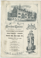
Merchant Taylors' School Club twenty first anniversary, half-yearly dinner, Tuesday, July 1, 1902, at Hotel Cecil Victoria Hall
Date
1902-07-01
Archival Collection
Description
Note: The Merchant Taylors' School Club was founded in 1881. The subscription to the club entitled members to two dinners annually, one in the summer and one in the winter Menu insert: Toasts; Officer lists; Music Programs Restaurant: Hotel Cecil (London, England) Location: London, England
Text
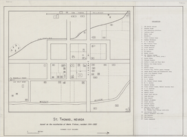
Map of St. Thomas, Nevada, circa 1933
Date
1930 to 1933
Archival Collection
Description
Hand-drawn map of St. Thomas, Nevada (ca. 1914-1932) which was abandoned in 1933 due to the construction of Hoover Dam and is now covered by Lake Mead, as remembered by Merle Frehner (a former resident of St.Thomas). Buildings and residences on map are numbered and explained in a key. "Mormon plat assumed." Scale: 1 1/2 in. = 300 ft.
Image
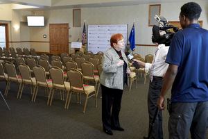
An event to mark a $3 million grant spanning five years from the United Health Foundation to the UNLV School of Medicine for building research programs and helping build three community clinics: digital photographs
Date
2016-04-05
Archival Collection
Description
Photographs from the University of Nevada, Las Vegas Creative Services Records (2010s) (PH-00388-05).
Image