Search Results
New Year's Eve dinner menu, Brigham's Hotel and Cafe, 1912 December 31
Level of Description
Item
Archival Collection
Bohn-Bettoni Menu Collection
To request this item in person:
Collection Number: MS-00793
Collection Name: Bohn-Bettoni Menu Collection
Box/Folder: Box 09
Collection Name: Bohn-Bettoni Menu Collection
Box/Folder: Box 09
Archival Component
New Year's Eve menu, The Seelbach, 1913 December 31 to 1914 January 01
Level of Description
Item
Archival Collection
Bohn-Bettoni Menu Collection
To request this item in person:
Collection Number: MS-00793
Collection Name: Bohn-Bettoni Menu Collection
Box/Folder: Box 09
Collection Name: Bohn-Bettoni Menu Collection
Box/Folder: Box 09
Archival Component
Department of Agriculture. Agriculture Year Book. Contains correspondence, 1979 January to 1979 May
Level of Description
File
Archival Collection
Howard Cannon Papers
To request this item in person:
Collection Number: MS-00002
Collection Name: Howard Cannon Papers
Box/Folder: Box 33 (96th Session)
Collection Name: Howard Cannon Papers
Box/Folder: Box 33 (96th Session)
Archival Component

Liz Smith, Geoscience Administrative Assistant III and President's Classified Employee of the Year on July 22, 2014: digital photographs
Date
2014-07-22
Archival Collection
Description
Photographs from the University of Nevada, Las Vegas Creative Services Records (2010s) (PH-00388-05). Client: Diane Russell, University Communications
Image
Williams, Kurt, Boys and Girls Club of America Boy of the Year, 1985 May 08
Level of Description
File
Archival Collection
Frank Mitrani Photographs
To request this item in person:
Collection Number: PH-00332
Collection Name: Frank Mitrani Photographs
Box/Folder: Box 20
Collection Name: Frank Mitrani Photographs
Box/Folder: Box 20
Archival Component
Paradise Rotary Club, Showboat Hotel, Man of the Year awards, 1980 March 27
Level of Description
File
Archival Collection
Frank Mitrani Photographs
To request this item in person:
Collection Number: PH-00332
Collection Name: Frank Mitrani Photographs
Box/Folder: Box 47
Collection Name: Frank Mitrani Photographs
Box/Folder: Box 47
Archival Component
Mack, Nate, B'nai B'rith Man of the Year, 1979 November 25
Level of Description
File
Archival Collection
Frank Mitrani Photographs
To request this item in person:
Collection Number: PH-00332
Collection Name: Frank Mitrani Photographs
Box/Folder: Box 06
Collection Name: Frank Mitrani Photographs
Box/Folder: Box 06
Archival Component
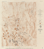
Map showing ground-water chemistry and hydrochemical facies, Nevada Test Site and vicinity, southern Nevada, 1965
Date
1965
Description
'United States Department of the Interior, Geological Survey. Professional paper 712-C, plate 3.' 'Prepared on behalf of the Atomic Energy Commission.' 'Base from U.S. Geological Survey Caliente, Death Valley, Goldfield, and Las Vegas, 1954.' 'Hydrochemistry by I. J. Winograd, 1965.' 'Interior--Geological Survey, Reston, Virginia--1975.' Relief shown by contours. Contour interval 200 feet. Shows township and range lines. Scale 1:250,000 (W 117°--W 115°/N 38°--N 36°). Series: Professional paper (Geological Survey (U.S.))
712-C. Issued as plate 3 from U.S. Geological Survey professional paper 712-C, Hydrogeologic and hydrochemical framework, south-central Great Basin, Nevada-California, with special reference to the Nevada Test Site, by I.J. Winograd, and William Thordarson, published in 1975 by the U.S. Geological Survey.
712-C. Issued as plate 3 from U.S. Geological Survey professional paper 712-C, Hydrogeologic and hydrochemical framework, south-central Great Basin, Nevada-California, with special reference to the Nevada Test Site, by I.J. Winograd, and William Thordarson, published in 1975 by the U.S. Geological Survey.
Image
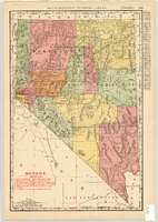
Map showing railroads in Nevada, 1904
Date
1904
Description
Relief shown by hachures. Added title: Rand McNally's new business map of Nevada. Shows range and township grid. Shows railroads. Color used to show boundaries of counties. Includes index to cities. On verso: Indexes to counties, lakes, mountains, rivers, towns, etc. Published by Rand McNally & Co. Scale [ca. 1:1,710,720]. 1 in. equals 27 miles (W 120°--W 114°/N 42°--N 35°). Originally published as pages 263 and 264 of Rand-McNally indexed atlas.
Text
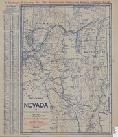
Sketch map of Nevada and the southeastern portion of California, 1906
Date
1906
Description
42 x 30 cm., fold. to 23 x 11 cm. Relief shown by hachures. Copyright: George S. Clason. "Compliments of D. Mackinzie & Company Incorporated, Mine Operators and Commission Brokers, Goldfield, Nevada." Company's locations in Goldfield and in Greenwater, California, are marked with red circles on the map. Includes index. Shows railroad routes. Original publisher: Clason Map Co..
Image