Search Results
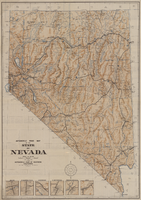
Automobile road map of the state of Nevada, circa 1930
Date
1930
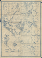
Description
Insets of major roads in Reno, Carson City, Tonopah, Las Vegas, Winnemucca, and Ely at bottom left of map. 'Prepared by the Route and Map Service Department, Automobile Club of Southern California.' 'Copyrighted by the Automobile Club of Southern California.' Scale [ca. 1:1,013,760]. 1 in. to approx. 16 miles. Indexes on map verso.
Text
Official road map of the State of Nevada, 1941
Date
1941
Archival Collection
Description
Compiled and published for free distribution by the Department of Highways, Carson City, Nevada. Board of Directors: Governor E.P. Carville, Chairman; Gray Mashburn, Member; Henry Schmidt, Member; Robert A. Allen, State Highway Engineer. Nevada Department of Highways
Image