Search Results

Geologic map of the Tippipah Spring quadrangle, Nye County, Nevada, 1963
Date
1963
Description
58 x 46 cm., on sheet 84 x 81 cm., folded in envelope 30 x 24 cm. Relief shown by contours and spot heights. "Geology by P.P. Orkild, 1959-60, paleotopography by D.L. Healey and C.H. Miller, 1959-60." Series statement from envelope. Includes description of map units, 2 col. cross sections, and quadrangle location map. "Prepared in cooperation with the U. S. Atomic Commission." Original publisher: Interior, Geological Survey, Series: Geologic quadrangle map GQ, Scale: 1:24 000.
Image

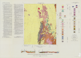
Geologic map of the Ammonia Tanks quadrangle, Nye County, Nevada, 1967
Date
1967
Description
58 x 46 cm., on sheet 84 x 100 cm., folded in envelope 30 x 24 cm. Relief shown by contours and spot heights. "Base by U.S. Geological Survey, 1961." "Geology mapped in 1961-65." "Contour interval 20 feet." Includes 3 col. cross sections, 1 index map, text with bibliography, and quadrangle location map. "Prepared in cooperation with the U. S. Atomic Commission." Original publisher: Interior, Geological Survey, Series: Geologic quadrangle map GQ, Scale: 1:24 000.
Image
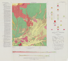
Geologic map of the Belted Peak quadrangle, Nye County, Nevada, 1967
Date
1967
Description
45 x 36 cm., on sheet 64 x 89 cm., fold. in envelope 30 x 24 cm. Relief shown by contours and spot heights. "Contour interval 40 feet." "Prepared in cooperation with the U.S. Atomic Energy Commission." "Geology mapped in 1962-63." Includes text, 2 col. cross sections, and quadrangle location map. Original publisher: U.S. Geological Survey, Series: Geologic quadrangle map GQ, Scale: 1:62 500.
Image
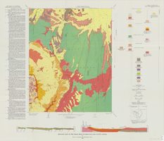
Geologic map of the Thirsty Canyon quadrangle, Nye County, Nevada, 1966
Date
1966
Description
57 x 46 cm., on sheet 83 x 91 cm., folded in envelope 30 x 24 cm. Relief shown by contours and spot heights. "Geology mapped in 1963." Includes 2 colored cross sections, index map, text, and quadrangle location map. "Prepared in cooperation with the U. S. Atomic Commission." Original publisher: Interior, Geological Survey, Series: Geologic quadrangle map GQ, Scale: 1:24 000.
Image
Geologic map of the Trail Ridge quadrangle, Nye County, Nevada, 1968
Date
1968
Description
58 x 46 cm., on sheet 79 x 91 cm., folded in envelope 30 x 24 cm. Relief shown by contours and spot heights. "Prepared in cooperation with the U.S. Atomic Energy Commission." "Base by U.S. Geological Survey, 1962." "Geology mapped in 1963." "Contour interval 20 feet." Includes text, 2 col. cross sections, quadrangle location map, and 1 index map. Original publisher: Interior, Geological Survey, Series: Geologic quadrangle map GQ, Scale: 1:24 000.
Image

Map of the territories of New Mexico, Arizona, Colorado, Nevada, and Utah, 1855
Date
1855
Description
29 x 36 cm. Relief shown by hachures. Prime meridians: Greenwich and Washington. "Entered according to act of Congress in the year 1855 by J.H. Colton & Co. in the Clerk's Office of the Dist. Office of the U.S. for the Southern. Dist. of New York." Hand colored. Decorative border. Atlas p. number in lower-right margin: 67. Shows routes of explorers, proposed railroad routes, wagon route, mail route, Indian reserves and mines. On verso: History and statistical view of Mexico. Original publisher: J.H. Colton.
Image
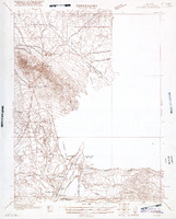
Map of Ely Range Quadrangle, Lincoln County, Nevada, 1921
Date
1921
Description
'Edition of 1921.' 'W. H. Herron, Acting Chief Geographer; Geo. R. Davis, Geographer In Charge; Topography by H. H. Hodgeson, N. E. Ballmer, and W. B. Upton, Jr.; Control by H. H. Hodgeson, Roscoe Reeves, and D. S. Birkett. Surveyed in 1916.' At top of map: ' Topography, State of Nevada.' At upper left corner: ' Department of the Interior, Albert B. Fall, Secretary; U.S. Geological Survey, George Otis Smith, Director.' Southern Nevada Mining Map Collection. 15 minute series (topographic) Nevada.
Image
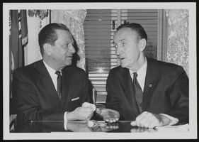
Howard Cannon and Senate Majority Leader Mike Mansfield meeting to plan the development of 150 million new silver dollars within the year: photographic print
Date
1964
Archival Collection
Description
From the Howard Cannon Photograph Collection (PH-00192)
Image
Topographic map of Goodsprings quadrangle, Nevada and California, 1919
Date
1919
Description
'R.B. Marshall, Chief Geographer; Geo. R. Davis, Geographer in charge; Topography by N.E. Ballmer and Roscoe Reeves; Control by J.E. Blackburn and L.F. Biggs. Surveyed in 1915-1916.' 'Edition of 1919.' Relief shown by hachures and spot heights. Title in lower right margin: Goodsprings. In center of top margin: Topography. Includes compilation diagram. Indicates location and density of cedar trees. Shows small portion of San Bernardino County, California. Published by U.S. Geological Survey. Scale 1:62,500 (W 115°35'00"--W 115°24'00"/N 36°02'30"--N 35°42'30"). 'Contour interval 50 feet. Datum is mean sea level.'
Text
Centennial Stories: A Leap Back, A Look Forward-100 Years of History-The Strip, CCTV-4 Clark County TV, 2009
Level of Description
File
Archival Collection
Scott Rayer Collection of Television Programs about Las Vegas, Nevada
To request this item in person:
Collection Number: MS-01130
Collection Name: Scott Rayer Collection of Television Programs about Las Vegas, Nevada
Box/Folder: Digital File 00
Collection Name: Scott Rayer Collection of Television Programs about Las Vegas, Nevada
Box/Folder: Digital File 00
Archival Component