Search the Special Collections and Archives Portal
Search Results

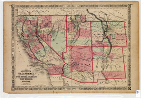
Map of California, Utah, Nevada, Colorado, New Mexico and Arizona, 1864
Date
1864
Description
'Johnson's California, also Utah, Nevada, Colorado, New Mexico, and Arizona, published by A.J. Johnson, New York.' 'Entered according to Act of Congress in the Year 1864, by A.J. Johnson in the Clerks Office of the District Court of the United States for the Southern District of New York.' Atlas page numbers in upper margin: 66-67. Relief shown by hachures. Prime meridians: Greenwich and Washington, D.C. Shows proposed railroads, locations of Indian tribes, natural features, counties, mines, mail routes, trails and routes of exploring expeditions. On verso: History and statistics of Mexico and Central America and statistics of national finances and the Post Office of the United States, 1860. Scale [ca. 1:3,484,800. 1 in. to ca. 55 miles] (W 123°--W 103°/N 42°--N 32°)
Text

UNLV Professor Brendan O'Toole, and an undergraduate intern from Rutgers University join Yong Dawson in helping to take measurements from Dawson's 4-year-old daughter Hailey Dawson: digital photographs
Date
2014-06-19
Archival Collection
Description
Photographs from the University of Nevada, Las Vegas Creative Services Records (2010s) (PH-00388-05). Client: Public Affairs, Engineering. UNLV Professor Brendan O'Toole, and an undergraduate intern from Rutgers University join Yong Dawson in helping to take measurements from Dawson's 4-year-old daughter Hailey Dawson in the Science and Engineering building June 19, 2014 at the University of Nevada, Las Vegas.
Image
Unknown author. Horse racing: war boom brings greatest betting year, Life 17(17), 1944 October 23
Level of Description
File
Archival Collection
UNLV Libraries Collection of Articles on Gaming and Las Vegas, Nevada Topics
To request this item in person:
Collection Number: MS-00626
Collection Name: UNLV Libraries Collection of Articles on Gaming and Las Vegas, Nevada Topics
Box/Folder: Box 10
Collection Name: UNLV Libraries Collection of Articles on Gaming and Las Vegas, Nevada Topics
Box/Folder: Box 10
Archival Component
Kelley, Elizabeth Lorain, "Validation of current body composition estimation equations for men over 60 years of age", 1992 Fall
Level of Description
Item
Archival Collection
University of Nevada, Las Vegas Theses, Dissertations, and Honors Papers
To request this item in person:
Collection Number: UA-00082
Collection Name: University of Nevada, Las Vegas Theses, Dissertations, and Honors Papers
Box/Folder: Box 081
Collection Name: University of Nevada, Las Vegas Theses, Dissertations, and Honors Papers
Box/Folder: Box 081
Archival Component
Blakey, Linda S, "Food Utilization and Habitat Preference of youn-of-the-year Largemouth Bass [Micripterus Salmoides] in the Atchafelaya Basin, Louisiana.", 1982
Level of Description
Item
Archival Collection
University of Nevada, Las Vegas Theses, Dissertations, and Honors Papers
To request this item in person:
Collection Number: UA-00082
Collection Name: University of Nevada, Las Vegas Theses, Dissertations, and Honors Papers
Box/Folder: Box 001
Collection Name: University of Nevada, Las Vegas Theses, Dissertations, and Honors Papers
Box/Folder: Box 001
Archival Component

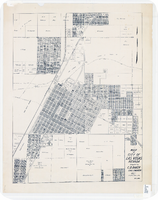
Map of city of Las Vegas, Nevada, October 1, 1940
Date
1940-10-01
Description
'Compiled by C.D. Baker, Oct. 1, 1940.' Scale [ca. 1:11,400]. 1 in. to 950 ft. Cadastral map.
Image
Text: transcript (with holograph notations), instructions and record booklet for 4-H for third year clothing construction and care, consists of U.S. Department of Agriculture Farmers' Bulletin, compiled by University of Nevada Agriculture Extension Division, 1926-1928
Level of Description
File
Archival Collection
Arlene Mathews Smith Papers
To request this item in person:
Collection Number: MS-00069
Collection Name: Arlene Mathews Smith Papers
Box/Folder: Box 01
Collection Name: Arlene Mathews Smith Papers
Box/Folder: Box 01
Archival Component
#71486: Agency Mentor-Protege Agreement of the Year, Nasa Small Business Industry Awards, April 6, 2017, 2017 April 06
Level of Description
Item
Archival Collection
University of Nevada, Las Vegas Creative Services Records (2010s)
To request this item in person:
Collection Number: PH-00388-05
Collection Name: University of Nevada, Las Vegas Creative Services Records (2010s)
Box/Folder: Digital File 01
Collection Name: University of Nevada, Las Vegas Creative Services Records (2010s)
Box/Folder: Digital File 01
Archival Component
Meterological, Stream-Discharge, and Water-Quality Data for Water Year 1992 from Two Basins in Central Nevada - USDOE, US Geological Survey, Open-File Report 94-456, 1995 July 13
Level of Description
File
Archival Collection
Yucca Mountain Site Characterization Office Collection
To request this item in person:
Collection Number: MS-00091
Collection Name: Yucca Mountain Site Characterization Office Collection
Box/Folder: Box 86
Collection Name: Yucca Mountain Site Characterization Office Collection
Box/Folder: Box 86
Archival Component

Map of Tonopah Mining District, Nevada, 1905
Date
1905
Description
In lower right corner: 'Copyrighed by Bradford & Bradford 1905.' Includes table of distances from Tonopah. Relief shown by hachures. Scale [ca. 1:15,600. 1 in. to approx. 1300 feet]. Library's copy has one section outlined in red pencil and 'Tonopah Victor' hand-printed on it in red pencil. Red pencil dots are on two other sections. '1905' and some illegible words written in pencil near title of map.
Image
Pagination
Refine my results
Content Type
Creator or Contributor
Subject
Archival Collection
Digital Project
Resource Type
Year
Material Type
Place
Language
Records Classification
