Search Results
Nevada Southern University diploma
Date
1964-06-03
Archival Collection
Description
Jon Eric Cobain's diploma, the first conferred by Nevada Southern University (later UNLV).
Text

Surficial geologic map of the Specter Range NW quadrangle, Nye County, Nevada, 1989
Date
1989
Description
58 x 47 cm., on sheet 74 x 81 cm., folded in envelope 30 x 24 cm. Relief shown by contours and spot heights. "Geology mapped in 1984-85." Includes text, bibliography, and location maps. "Prepared in cooperation with the U. S. Deparment of Energy." "Base from U. S. Geological Survey, 1961. Photorevised 1983. 10,0000-foot grid ticks based on Nevada coordinate system, central zone. 1000-meter Universal Transverse Mercator grid ticks, zone 11, shown in blue." Original publisher: U. S. Geological Survey, Series: Miscellaneous investigations series map I, Scale: 1:24 000.
Image
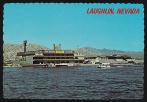
The Nevada Club in Laughlin, Nevada: postcard
Date
1940 (year approximate) to 1990 (year approximate)
Archival Collection
Description
From the Harvey's Hotel and Casino Postcard Collection (PH-00367) -- The Nevada Club in Laughlin, Nevada. Across the Colorado River from Bullhead City, Arizona is the site of many casinos which provide free ferry boat rides.
Image

Map showing second stage plan of development for Southern Nevada Water Project, March 1981
Date
1981-03
Description
'United States Department of the Interior, Bureau of Reclamation.' 'June 1976. Revised March 1981.' 'Map No. 952-300-203.' 'Exhibit I.' Includes inset location map for project area. Scale [ca. 1:126,720. 1 in. to approx. 2 miles] . United States Department of the Interior, Bureau of Reclamation
Image
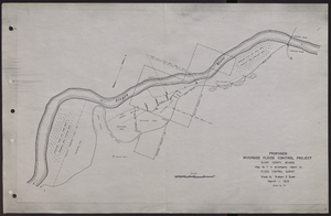
Map of proposed flood control project on the Virgin River in Clark County, Nevada, March, 1934
Date
1934-03
Archival Collection
Description
'Map no. 7 to accompany report on flood control survey. Made by Graham S. Quate. March 1934. Drawn by T.K.' Scale [ca. 1:15, 600. 1 in.=approx. 1,300 feet]. Relief shown by hachures. North oriented to upper right corner. Library's copy has hand-drawn map and notes in pencil on verso.
Image

Bank of Nevada located in Las Vegas, Nevada: photographic print
Date
1930
Archival Collection
Description
From the UNLV Libraries Single Item Accession Photograph Collection (PH-00171). "I worked as a teller in the Bank of Nevada for a year, 1930 1st and Fremont." Lesley W. Edwards
Image

Topographic map of Nevada-California, Las Vegas quadrangle, March 1908
Date
1908-03
Description
'Edition of Mar. 1908.' 'E.M. Douglas, geographer in charge; Topography and triangulation by R.H. Chapman, B.D. Stewart, J.E. Blackburn, and D.F.C. Moor. Surveyed in 1906-1907.' Scale 1:250,000 (W 116°00--W 115°00/N 37°00--N 36°00). Relief shown by contours and spot heights. Title in lower-right corner: Las Vegas. Contour interval 100 feet. Datum is mean sea level. "Topography"--Center of top margin. Text about the Topographic Maps of the United States series and symbols used on map on verso. U.S. Geological Survey
Text
#69372: UNLV College of Education Alum of the Year and Clark County School District Superintendent Pat Skorkowski poses October 8, 2013 at Hancock Elementary School., 2013 October 08
Level of Description
File
Archival Collection
University of Nevada, Las Vegas Creative Services Records (2010s)
To request this item in person:
Collection Number: PH-00388-05
Collection Name: University of Nevada, Las Vegas Creative Services Records (2010s)
Box/Folder: Digital File 00
Collection Name: University of Nevada, Las Vegas Creative Services Records (2010s)
Box/Folder: Digital File 00
Archival Component
Clark County, Nevada Financial Reports
Identifier
MS-00670
Abstract
The Clark County, Nevada Financial Reports (1974-1982) include yearly financial reports prepared by the Office of the Comptroller.
Archival Collection
Nevada Women's History Project bylaws, policies, and procedures
Date
1996 to 1997
Archival Collection
Description
Folder from the Nevada Women's History Project Records (MS-00406).
Text