Search Results
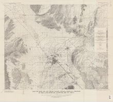
Map of part of Las Vegas Valley, Nevada, showing changes in the land-surface altitude, 1935 to 1940-41
Date
1965
Description
Genre/Form: Topographic map. Scale 1:96,000 (W 115°30´--W 114°45´/N 36°30´--N 36°00´). 1 map ; 58 x 70 cm. Series: Water-supply paper (Washington, D.C.) ; 1780. Relief shown by contours. "After C.R. Longwell (written communication, 1954, fig. 30)." Originally published as plate 12 of Available water supply of the Las Vegas ground-water basin, Nevada, by Glenn T. Malmberg, published by the Geological Survey in 1965 as its Water-supply paper 1780. Includes township and range lines. Interior, Geological Survey
Image
Nevada Consolidated Copper Company Photograph Albums
Identifier
PH-00441
Abstract
The Nevada Consolidated Copper Company Photograph Albums (1906-1907) contain two photograph albums from the mining company's chief engineer's office. The photograph albums include cyanotype and black-and-white photographs depicting the construction of the smelting plant, equipment, railroad, and landscape of Ruth, Nevada.
Archival Collection
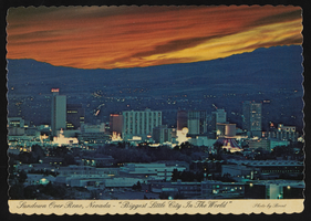
The Reno skyline, Reno, Nevada: postcard
Date
1979 (year approximate)
Archival Collection
Description
From the Harvey's Hotel and Casino Postcard Collection (PH-00367) -- An veiw of the Reno skyline, Nevada with the caption, "Sundown over Reno, Nevada - 'Biggest Little City in the World'" circa 1979
Image
Japanese in Nevada
Level of Description
File
Archival Collection
Sue Fawn Chung Collection on Asians in Nevada
To request this item in person:
Collection Number: MS-00332
Collection Name: Sue Fawn Chung Collection on Asians in Nevada
Box/Folder: N/A
Collection Name: Sue Fawn Chung Collection on Asians in Nevada
Box/Folder: N/A
Archival Component
Gabbs, Nevada
Level of Description
File
Archival Collection
Henderson Public Library Photograph Collection on Henderson, Nevada
To request this item in person:
Collection Number: PH-00254
Collection Name: Henderson Public Library Photograph Collection on Henderson, Nevada
Box/Folder: N/A
Collection Name: Henderson Public Library Photograph Collection on Henderson, Nevada
Box/Folder: N/A
Archival Component
Nevada Club
Level of Description
File
Archival Collection
Bob Hampton Photographs of Construction Projects in Southern Nevada
To request this item in person:
Collection Number: PH-00362
Collection Name: Bob Hampton Photographs of Construction Projects in Southern Nevada
Box/Folder: N/A
Collection Name: Bob Hampton Photographs of Construction Projects in Southern Nevada
Box/Folder: N/A
Archival Component
Nevada history
Level of Description
File
Archival Collection
Scott Rayer Collection of Television Programs about Las Vegas, Nevada
To request this item in person:
Collection Number: MS-01130
Collection Name: Scott Rayer Collection of Television Programs about Las Vegas, Nevada
Box/Folder: N/A
Collection Name: Scott Rayer Collection of Television Programs about Las Vegas, Nevada
Box/Folder: N/A
Archival Component
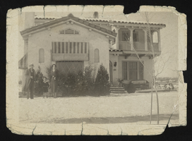
Albert S. Henderson's home in Las Vegas, Nevada: photographic print
Date
1860 (year approximate) to 1959 (year approximate)
Archival Collection
Description
From the Albert S. Henderson Photograph Collection (PH-00317).
Image
People gambling in Las Vegas, Nevada, undated
Level of Description
File
Archival Collection
L. F. Manis Photograph Collection
To request this item in person:
Collection Number: PH-00100
Collection Name: L. F. Manis Photograph Collection
Box/Folder: Box 02
Collection Name: L. F. Manis Photograph Collection
Box/Folder: Box 02
Archival Component
Album 4: the Wilson and Park families camping, possibly near Mt. Charleston, Nevada: photographic prints
Date
1900 (year approximate) to 1939 (year approximate)
Archival Collection
Description
From the Maurine and Fred Wilson and Dr. William S. Park Photograph Albums (PH-00222) -- Album 4
Image