Search Results
Postcard: stagecoach in the desert, approximately 1900-1920
Level of Description
File
Archival Collection
Fred and Maurine Wilson Photograph Collection
To request this item in person:
Collection Number: PH-00014
Collection Name: Fred and Maurine Wilson Photograph Collection
Box/Folder: Folder 14 (Restrictions apply)
Collection Name: Fred and Maurine Wilson Photograph Collection
Box/Folder: Folder 14 (Restrictions apply)
Archival Component
Photographic prints and negatives, approximately 1900 to 1920
Level of Description
File
Archival Collection
Arthur Walker Gregory Photograph Collection
To request this item in person:
Collection Number: PH-00197
Collection Name: Arthur Walker Gregory Photograph Collection
Box/Folder: Folder 01, Box SH-026
Collection Name: Arthur Walker Gregory Photograph Collection
Box/Folder: Folder 01, Box SH-026
Archival Component
Extension Work Annual Narrative Report for Clark, Lincoln, and White Pine Counties, Nevada, 1925 November 01 to 1926 October 31
Level of Description
File
Archival Collection
John Wittwer Collection on Agriculture in Nevada
To request this item in person:
Collection Number: MS-00181
Collection Name: John Wittwer Collection on Agriculture in Nevada
Box/Folder: Box 03
Collection Name: John Wittwer Collection on Agriculture in Nevada
Box/Folder: Box 03
Archival Component
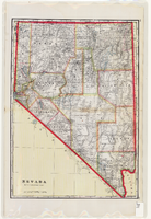
Map of Nevada, circa 1909
Date
1907 to 1911
Description
'Geo. F. Cram, engraver and publisher.' Scale [ca. 1:1,584,000. 1 in. to approx. 25 miles] (W 120°--W 114°/N 42°--N 35°). Relief shown by hachures and spot heights. Counties outlined in color. Shows railroads, forest reserves, mines, Indian reservations, and springs. Shows range and township grid. Indexes on verso to both Nevada and Utah maps. Atlas p. numbers in right margin: 124-125. G.F. Cram.
Text
Photocopy of portrait of A.L. Fitzgerald, Nye County Judge from 1887-1900: photographic print, approximately 1900 to 1999
Level of Description
Item
Archival Collection
UNLV Libraries Single Item Accession Photograph Collection
To request this item in person:
Collection Number: PH-00171
Collection Name: UNLV Libraries Single Item Accession Photograph Collection
Box/Folder: Folder 03
Collection Name: UNLV Libraries Single Item Accession Photograph Collection
Box/Folder: Folder 03
Archival Component
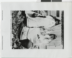
Photograph of Shoshone women, Tonopah (Nev.), early 1900s
Date
1900 to 1920
Archival Collection
Description
Transcribed from the picture, "Shoshone - 5. Shoshone woman and daughter of Tonopah displaying willow water bottles. Inter-Tribal Council of Nevada. Courtesy of Nevada Historical Society."
Image
Las Vegas Ranch, approximately 1900-1940
Level of Description
File
Archival Collection
Helen J. Stewart Photographs
To request this item in person:
Collection Number: PH-00104
Collection Name: Helen J. Stewart Photographs
Box/Folder: Oversized Box SH-060
Collection Name: Helen J. Stewart Photographs
Box/Folder: Oversized Box SH-060
Archival Component
Photographic prints and negatives, approximately 1900 to 1930
Level of Description
File
Archival Collection
Sunnie Gillette Photograph Collection
To request this item in person:
Collection Number: PH-00266
Collection Name: Sunnie Gillette Photograph Collection
Box/Folder: Folder 01, Folder 02, Box SH-031
Collection Name: Sunnie Gillette Photograph Collection
Box/Folder: Folder 01, Folder 02, Box SH-031
Archival Component
Photographic prints and negatives, approximately 1900 to 1915
Level of Description
File
Archival Collection
David Farnsworth Photograph Collection
To request this item in person:
Collection Number: PH-00290
Collection Name: David Farnsworth Photograph Collection
Box/Folder: Folder 01, Box SH-032
Collection Name: David Farnsworth Photograph Collection
Box/Folder: Folder 01, Box SH-032
Archival Component