Search Results
#68895: A reception to honor English professor Felicia Campbell's 50 years of teaching at UNLV was held in the Tam Alumni Center November 8, 2012 at the University of Nevada, Las Vegas, 2012 November 08
Level of Description
File
Archival Collection
University of Nevada, Las Vegas Creative Services Records (2010s)
To request this item in person:
Collection Number: PH-00388-05
Collection Name: University of Nevada, Las Vegas Creative Services Records (2010s)
Box/Folder: Digital File 00
Collection Name: University of Nevada, Las Vegas Creative Services Records (2010s)
Box/Folder: Digital File 00
Archival Component
UNLV College of Education Alum of the Year and Clark County School District Superintendent Pat Skorkowski poses October 8, 2013 at Hancock Elementary School: digital photographs
Date
2013-10-08
Archival Collection
Description
Photographs from the University of Nevada, Las Vegas Creative Services Records (2010s) (PH-00388-05). Client: UNLV Magazine, Marketing and Public Relations
Image
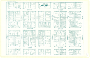
Map of downtown Las Vegas, Nevada, circa 1952-1955
Date
1952 to 1955
Description
Title in upper left and right margins: Las Vegas, Nevada. Identifies business tenants in the downtown area and includes property valuations, measurements, addresses, etc. Cadastral map. Oriented with north to the lower right.Text, illustrations, aerial photos, and ancillary map of the Las Vegas Strip on verso. Cataloger has determined date of map to be between 1952 and 1955 because the Sahara and the Sands Casinos are shown on the verso of the map, and they both opened in 1952, but the Riviera and the Dunes opened in 1955, and they are not shown on the map. Also, the Hotel Last Frontier is shown on the verso of the map, and its name was changed to New Frontier in 1955. Note: Many of the property names and addresses are erroneous when compared to Las Vegas business directories from the same period.
Image
#70334: UNLV Classified Staff Member of the Year third runner up Erin Azua poses in the Student Wellness Center July 2, 2015 at the University of Nevada, Las Vegas., 2015 July 02
Level of Description
File
Archival Collection
University of Nevada, Las Vegas Creative Services Records (2010s)
To request this item in person:
Collection Number: PH-00388-05
Collection Name: University of Nevada, Las Vegas Creative Services Records (2010s)
Box/Folder: Digital File 00
Collection Name: University of Nevada, Las Vegas Creative Services Records (2010s)
Box/Folder: Digital File 00
Archival Component
Photocopy of the 1992 article "Ninety Years and Counting" from Rafu Shimpo magazine, approximately 1992 to 1999
Level of Description
File
Archival Collection
Sue Fawn Chung Collection on Asians in Nevada
To request this item in person:
Collection Number: MS-00332
Collection Name: Sue Fawn Chung Collection on Asians in Nevada
Box/Folder: Box 02
Collection Name: Sue Fawn Chung Collection on Asians in Nevada
Box/Folder: Box 02
Archival Component
Regional Transportation Commission of Clark County: "Transportation Improvement Program Fiscal Years 1991-1993", 1990 February 08
Level of Description
File
Archival Collection
Bruce Turner Collection on Transportation and Water in Southern Nevada
To request this item in person:
Collection Number: MS-00648
Collection Name: Bruce Turner Collection on Transportation and Water in Southern Nevada
Box/Folder: Box 30
Collection Name: Bruce Turner Collection on Transportation and Water in Southern Nevada
Box/Folder: Box 30
Archival Component
General education, Faculty Institute on Research Based Learning, Faculty Institute First and Second Year Seminars, 2010-2013
Level of Description
File
Archival Collection
University of Nevada Las Vegas Dean of Libraries Records
To request this item in person:
Collection Number: UA-00072
Collection Name: University of Nevada Las Vegas Dean of Libraries Records
Box/Folder: Box 14 (Restrictions apply)
Collection Name: University of Nevada Las Vegas Dean of Libraries Records
Box/Folder: Box 14 (Restrictions apply)
Archival Component
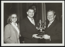
Howard Cannon presents to Malvin Matthews the American Training Association Million Miles Driver of the Year Award: photographic print
Date
1980-02
Archival Collection
Description
From the Howard Cannon Photograph Collection (PH-00192). Stamped on verso: "Photo by: Ankers Capitol Photographers 316 F Street, N.E. Wash., D.C. 20002 Phone 202/543-2484"
Image
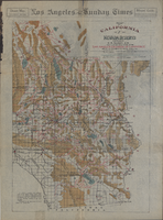
Map of California and Nevada deserts, 1905
Date
1905
Description
'Compiled by G.E. Bailey, E.M. Issued under the auspices of the the Los Angeles Chamber of Commerce and the supervision of its mining committee, Dan Murphy, H.Z. Osborne, Geo. W. Parsons, F.W. Braun, O.P. Posey, 1905.' 'A carefully prepared and authentic map of the desert mining region tributary of Los Angeles, embracing portions of Lincoln, Nye and Esmeralda counties, Nevada, showing location of all water supplies.' At top of page: 'Desert map. California-Nevada'. 'Miner's guide. Springs and waterholes.' Relief shown by hachures. Shows range and township grid. Scale indeterminable (W 119°--W 114°/N 37°--N 33°).
Image
T-Shirt Color: Gray; Front: 25 Years Canton TWP 52 Fire Rescue 1976 2001, Fire Emblem W/Fire Equip; Back: Canton Company 52 Fire Rescue Celebrating 25 Years Of Excellence, Two Fire Engines, approximately 2001-2012
Level of Description
File
Archival Collection
New York-New York Hotel and Casino 9-11 Heroes Tribute Collection
To request this item in person:
Collection Number: MS-00459
Collection Name: New York-New York Hotel and Casino 9-11 Heroes Tribute Collection
Box/Folder: Box 453
Collection Name: New York-New York Hotel and Casino 9-11 Heroes Tribute Collection
Box/Folder: Box 453
Archival Component