Search Results

Map of well locations, Las Vegas Valley, Nevada, 1975
Date
1976
Description
'Cartography by Marj Thielke.' 'Prepared in cooperation with the State of Nevada, Department of Conservation and Natural Resources, Division of Water Resources.' Relief shown by contours. Shows township and range lines. Originally published as Plate 1 in Water-level changes associated with ground-water development in Las Vegas Valley, Nevada, 1971-75 : fourth progress report--summary of data / by James R. Harrill, published in 1976 by the Department of Conservation and Natural Resources, Division of Water Resources, as volume 22 of Water resources-information series report. Scale [ca. 1:69,696. 1 in.=approx. 1.1 miles] (W 115°20´--W 115°00´/N 36°20´--N 36°00´).
Image
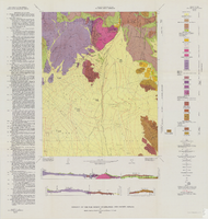
Geology of the Oak Spring Quadrangle, Nye County, Nevada, 1963
Date
1963
Description
58 x 46, on sheet 88 x 84 cm., fold. in envelope 30 x 24 cm. Relief shown by contours and spot heights. "Contour interval 20 feet." "Prepared in cooperation with the U.S. Atomic Energy Commission." Title on envelope: Geologic map of the Oak Spring Quadrangle, Nye County, Nevada. Includes 3 col. cross sections, text, and quadrangle location map. Original publisher: Interior, Geological Survey, Series: Geologic quadrangle map GQ, Scale: 1:24 000.
Image

Margaret Covelli, chief nursing officer at Spring Valley Hospital and Medical Center is the School of Nursing Alumni of the Year. August 11, 2015: digital photographs
Date
2015-08-11
Archival Collection
Description
Photographs from the University of Nevada, Las Vegas Creative Services Records (2010s) (PH-00388-05).
Image

Joseph Morgan, College of Education Educational and Clinical Studies professor was named 2015 Alumi Faculty Member of the Year on September 23, 2015: digital photographs
Date
2015-09-23
Archival Collection
Description
Photographs from the University of Nevada, Las Vegas Creative Services Records (2010s) (PH-00388-05).
Image
NDE (Nevada Department of Education) 2001. "Nevada Public Schools Four Year Comparison of Enrollments End of First School Month," Carson City, Nevada: Department of Education. Accessed December 11, 2001. http://www.nde.state.nv.us/admin.html, 2001
Level of Description
File
Archival Collection
Environmental Radiation Protection Standards for Yucca Mountain, Nevada
To request this item in person:
Collection Number: MS-00603
Collection Name: Environmental Radiation Protection Standards for Yucca Mountain, Nevada
Box/Folder: Box 41
Collection Name: Environmental Radiation Protection Standards for Yucca Mountain, Nevada
Box/Folder: Box 41
Archival Component
#68878: UNLV Homecoming College Alumnus of the Year awards are presented by Alumni Association President Sandra Phillips Johnson November 2, 2012 at the University of Nevada, Las Vegas, 2012 November 02
Level of Description
File
Archival Collection
University of Nevada, Las Vegas Creative Services Records (2010s)
To request this item in person:
Collection Number: PH-00388-05
Collection Name: University of Nevada, Las Vegas Creative Services Records (2010s)
Box/Folder: Digital File 00
Collection Name: University of Nevada, Las Vegas Creative Services Records (2010s)
Box/Folder: Digital File 00
Archival Component
Landscape, Grounds & Arboretum facility supervisor Sandra Obenour-Dowd was named the Classified Staff Rookie of the Year on August 18, 2011: digital photographs
Date
2011-08-18
Archival Collection
Description
Photographs from the University of Nevada, Las Vegas Creative Services Records (2010s) (PH-00388-05). Client: Shane Bevell, Marketing and Public Relations
Image
David Copperfield, "15 Years of Magic," CBS-TV, 1994 May 12
Level of Description
File
Scope and Contents
Additional information from donor: With James Earl Jones and supermodel Claudia Schiffer
Archival Collection
Scott Rayer Collection of Television Programs about Las Vegas, Nevada
To request this item in person:
Collection Number: MS-01130
Collection Name: Scott Rayer Collection of Television Programs about Las Vegas, Nevada
Box/Folder: Digital File 00
Collection Name: Scott Rayer Collection of Television Programs about Las Vegas, Nevada
Box/Folder: Digital File 00
Archival Component
#72185: Elaine Anderson, the executive assistant in the Faculty Affairs office is THE Classified Employee of the Year, 2018 July 16
Level of Description
Item
Archival Collection
University of Nevada, Las Vegas Creative Services Records (2010s)
To request this item in person:
Collection Number: PH-00388-05
Collection Name: University of Nevada, Las Vegas Creative Services Records (2010s)
Box/Folder: Digital File 01
Collection Name: University of Nevada, Las Vegas Creative Services Records (2010s)
Box/Folder: Digital File 01
Archival Component
#72730: First year physical therapy students enjoy a spring day studying outdoors, 2019 March 27
Level of Description
Item
Archival Collection
University of Nevada, Las Vegas Creative Services Records (2010s)
To request this item in person:
Collection Number: PH-00388-05
Collection Name: University of Nevada, Las Vegas Creative Services Records (2010s)
Box/Folder: Digital File 01
Collection Name: University of Nevada, Las Vegas Creative Services Records (2010s)
Box/Folder: Digital File 01
Archival Component