Search Results
Donald Cowper Henderson, May Stephen Henderson Murray, Nancy Henderson, Margaret Henderson Martin, and their mother Mary, San Bernardino, California, approximately 1900-1905
Level of Description
Archival Collection
Collection Name: Fayle Family Photographs
Box/Folder: Folder 01
Archival Component
"Valcalda Mine and Mill [?] Blair" View of mining operations with a road leading between two sides of a small valley: glass plate negative, approximately 1900 to 1909
Level of Description
Archival Collection
Collection Name: E. W. Smith Glass Plate Negatives
Box/Folder: Box 02
Archival Component
William V. Wright Collection of Nevada Postcards
Identifier
Abstract
The William V. Wright Collection of Nevada Postcards contains picture postcards of towns and buildings in Nevada from 1900 to 1975. The postcards primarily depict casinos, hotels, and other attractions in Las Vegas, Nevada and Reno, Nevada. The postcards also depict post offices, landscapes, mines, and the Hoover (Boulder) Dam.
Archival Collection
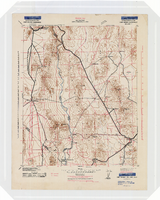
Topographic map of the Camp Mohave quadrangle in California, Nevada and Arizona, 1942
Date
Description
Image
Southern Nevada Educators Photograph Collection
Identifier
Abstract
The Southern Nevada Educators Photograph Collection consists of reproduction black-and-white photographic prints and negatives that Donna Andress compiled. The majority of the images are portraits of educators in Southern Nevada, primarily educators who have schools in Clark County, Nevada named after them. Other portraits depict prominent Las Vegas citizens, including Leva and William Beckley.
Archival Collection
George Lockhart in his office. His right hand is wrapped in gauze. The inscription on the back of the photo reads: "George Lockhart, son of Thomas Lockhart, owner of Florence Mine, Goldfield, Nevada. In office where I worked for Davis & Shoemaker": photographic print, approximately 1900-1915
Level of Description
Archival Collection
Collection Name: C. A. Earle Rinker Photograph Collection of Goldfield, Nevada
Box/Folder: Folder 02
Archival Component

Map of California, Nevada, Utah, Colorado, Arizona & New Mexico, circa 1867
Date
Description
Image
Photographic print, annotated: "Arrival of Tex Rickards' drill for mining and water, Rawhide Northern Water Company." Handwritten note on back: photographic print, approximately 1900-1915
Level of Description
Archival Collection
Collection Name: C. A. Earle Rinker Photograph Collection of Goldfield, Nevada
Box/Folder: Folder 06
Archival Component
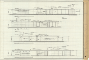
Architectural drawing of the Rugar residence, Las Vegas, Nevada, exterior elevations, December 31, 1962
Date
Archival Collection
Description
Drawings of exterior elevations A, B, C and D for the Rugar residence, Las Vegas, Nevada. "Sheet no. 8 of 20." "James Brooks McDaniel, A.I.A., Architect." "Job no. R62-1." "Drawn by J.M. Checked by J.Mc." "Scale: 1/4" = 1'-0"."
Site Name: Rugar residence
Image