Search Results
Congress Hotel, Dinner by the Chicago Association of Commerce in Honor of the Board of Trade of the City Chicago, menu, approximately 1900 to 1930
Level of Description
File
Archival Collection
UNLV University Libraries Menu Collection
To request this item in person:
Collection Number: MS-00436
Collection Name: UNLV University Libraries Menu Collection
Box/Folder: Box 106
Collection Name: UNLV University Libraries Menu Collection
Box/Folder: Box 106
Archival Component
The Royal Society anniversary dinner menu, St. Andrew's day, at the Hôtel Métropole, Whitehall Rooms, 1900 November 30
Level of Description
Item
Archival Collection
Bohn-Bettoni Menu Collection
To request this item in person:
Collection Number: MS-00793
Collection Name: Bohn-Bettoni Menu Collection
Box/Folder: Box 06
Collection Name: Bohn-Bettoni Menu Collection
Box/Folder: Box 06
Archival Component

Map of Las Vegas and vicinity, Clark County, Nevada, December 1954
Date
1954-12
Description
'1955 map of Las Vegas and vicinity, Clark County, Nevada.' '4th issue, December 1954.' Cadastral map..
Image
International Food Service Executives Association past presidents Frank Knapp, William R. Richter, Fred Klooz, and other unidentified men: photographic print, approximately 1925 to 1939
Level of Description
Item
Archival Collection
International Food Service Executives Association Photograph Collection
To request this item in person:
Collection Number: PH-00363
Collection Name: International Food Service Executives Association Photograph Collection
Box/Folder: Oversized Box SH-068
Collection Name: International Food Service Executives Association Photograph Collection
Box/Folder: Oversized Box SH-068
Archival Component
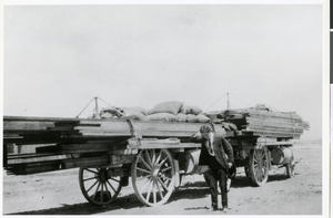
Photograph of Jake Beckley, partner with Ed Von Tobel, Sr., next to supply wagon, LAs Vegas, circa 1900s
Date
1900 to 1909
Archival Collection
Description
Jake Beckley, partner with Ed Von Tobel, Sr., is shown next to supply wagon on its way to one of the mining camps of the Rhyolite or Beatty Districts. Physical object has an insert containg additional biographical information.
Image
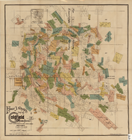
Map of the Goldfield Mining District, Nye and Esmeralda Counties, Nevada, 1905
Date
1905
Description
Copyright 1905 by Elmer J. Chute, E.M. Goldfield, Nev. In lower right corner: "Designed and drawn by R.W. Griswold." Includes inset location map; Includes township and range grid. Scale [ca. 1:20, 400. 1 in.=aprrox. 1,700 feet]
Image

Map of Las Vegas, Nevada and surrounding Bureau of Land Management areas to the west and north, 1994
Date
1994
Description
'BLM edition, 1994.' 'Surface management status; mineral management status.' '1:100,000-scale topographic map showing highways, roads and other manmade structures; water features; contours and elevations in meters with conversions to feet; BLM recreation sites.' 'Edited and published by the Bureau of Land Management. Base map prepared by the U.S. Geological Survey.' I53:11/4-2
Text
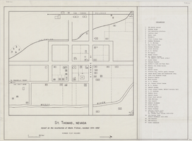
Map of St. Thomas, Nevada, circa 1933
Date
1930 to 1933
Archival Collection
Description
Hand-drawn map of St. Thomas, Nevada (ca. 1914-1932) which was abandoned in 1933 due to the construction of Hoover Dam and is now covered by Lake Mead, as remembered by Merle Frehner (a former resident of St.Thomas). Buildings and residences on map are numbered and explained in a key. "Mormon plat assumed." Scale: 1 1/2 in. = 300 ft.
Image
Main Street, Goldfield, Nevada, postcard
Description
Postcard of Main Street, Goldfield, Nevada.
Four unidentified men standing outside Cassaway & Cope Hatters & Cleaners: photographic print, approximately 1900 to 1937
Level of Description
File
Archival Collection
Nevada Mining Photograph Collection
To request this item in person:
Collection Number: PH-00361
Collection Name: Nevada Mining Photograph Collection
Box/Folder: Oversized Box 22 (Restrictions apply)
Collection Name: Nevada Mining Photograph Collection
Box/Folder: Oversized Box 22 (Restrictions apply)
Archival Component