Search Results
Monte-Carlo Casino located in Monaco, two views exterior and interior: photographic prints, approximately 1900 to 1999
Level of Description
Archival Collection
Collection Name: UNLV Libraries Single Item Accession Photograph Collection
Box/Folder: Flat File 24
Archival Component

Map of Argentite Red Mountain Mining District, Esmeralda County, Nevada, circa 1908-1913
Date
Description
Image

Original plat, townsite of Las Vegas, Lincoln Co., Nevada, January 13, 1905
Date
Description
Subtitle: 'Embracing the N. 1/2 of S.W. 1/4 Sec. 27 Township 20S. R.61E. Mt. Diablo Meridian.' 'Book 1, page 17A" handwritten in lower right corner. Signed by Henry Lee, County Recorder, Lincoln County Nevada. 'Filed at request of J.T. Williams, January 13th A.D. 1905.' Backwards handwriting on right side. Map has a Lincoln County seal on the bottom near the center. In the dedication J.T. McWilliams states that he has surveyed and platted the townsite of Las Vegas subject to the right of way of the San Pedro, Los Angeles and Salt Lake Railroad Company. He signed the dedication on Jan. 13, 1905, and it was signed by witnesses Scale [ca. 1:2,520? 1 inch to approx. 210 feet?]. Copy of a blueline print.
Image
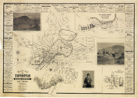
Map of Tonopah Mining District, Nye County, Nevada, 1902
Date
Description
Text

Map of Las Vegas Valley, Clark County, Nevada, 1954
Date
Description
Image
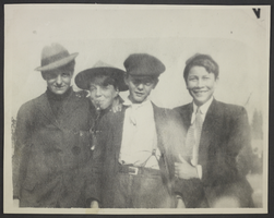
Photograph of Earl Benton, Hoot Gibson, Lester Stocker, and Roy Flood, Los Angeles, circa 1900-1905
Date
Archival Collection
Description
Image
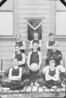
Film transparency of the boys basketball team for Clark County High School, Las Vegas, circa early 1900s
Date
Archival Collection
Description
Image

Film transparency of the girls basketball team for Clark County High School, Las Vegas, circa early 1900s
Date
Archival Collection
Description
Image
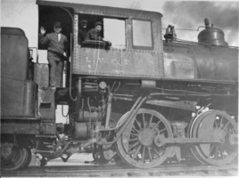
Film transparency of a Las Vegas and Tonopah Railroad Company train car, Las Vegas, circa early 1900s
Date
Archival Collection
Description
Image
J. Ross Clark, Miriam Clark, and James Ross Clark II: photographic prints and negatives, approximately 1900 to 1920
Level of Description
Archival Collection
Collection Name: J. Ross Clark Photograph Collection
Box/Folder: Folder 01, Box SH-023, Binder PB-003
Archival Component