Search Results

Map of California, Utah, Nevada, Colorado, New Mexico and Arizona, 1864
Date
1864
Description
'Johnson's California, with Utah, Nevada, Colorado, New Mexico, and Arizona, published by Johnson and Ward.' 'Entered according to Act of Congress in the Year 1864 by A.J. Johnson in the Clerks Office of the District Court of the United States for the southern district of New York.' Atlas page numbers in upper margin: 66-67. This is probably plate 67 from Johnson's New Illustrated Family Atlas, published in New York by Johnson & Ward in 1864. Shows natural features, locations of Indian tribes, proposed railroad routes, routes of explorers, trails, county boundaries and populated places ; "." ; Relief shown by hachures ; Prime meridians: Greenwich and Washington ; In top margin: 66-67 ; Hand colored ; On verso: Historical and statistical view of Mexico and central America (p. 79) and Historical and statistical view of the United States, 1860 (p. 78) Scale [ca. 1:3,484,800]. 1 in. to ca. 55 miles (W 124°--W 102°/N 42°--N 32°)
Text

Map of the state of Nevada to accompany the annual report of the Commr. Genl. Land Office, October 2, 1866
Date
1866-10-02
Description
'Department of the Interior, General Land Office, October 2nd, 1886, [signed] Jos. S. Wilson, Commissioner.' 'The Major & Knapp Eng. Mfg. & Lith. Co. 71 Broadway, N.Y.' Relief shown by hachures. Hand colored. Shows silver, gold, and copper mines. Scale [1:1,140,480]. 18 miles to an in. (W 120°--W 114°/N 42°--N 35°)
Image

Plat showing original townsite and subdivisions, Las Vegas, Lincoln County, Nevada, May 1905
Date
1905-05
Description
Land owned by the San Pedro, Los Angeles & Salt Lake Railroad is outlined. Scale: [ca. 1:12,000]. 1 inch = 1,000 feet. Cadastral map. Blueline print. Additional copy available in the J.T. McWilliams manuscript collection
Image
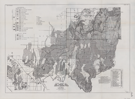
General geologic map of the Corners area, Arizona-Nevada-Utah, April 15, 1952
Date
1952-04-15
Archival Collection
Description
46 x 65 cm. "IAPG guide book #7. General plate #1." "April 15, 1952." Includes bibliographic references and index of drilled wells Includes township and range grid. "Drawn by Oscar Baide, Jack Harde." "Compiled by I.A.P.G. under direction of L.F. Wells." Original publisher: I.A.P.G..
Image

Map of California, Utah, Nevada, Colorado, New Mexico and Arizona, 1864
Date
1864
Description
'Johnson's California, also Utah, Nevada, Colorado, New Mexico, and Arizona, published by A.J. Johnson, New York.' 'Entered according to Act of Congress in the Year 1864, by A.J. Johnson in the Clerks Office of the District Court of the United States for the Southern District of New York.' Atlas page numbers in upper margin: 66-67. Relief shown by hachures. Prime meridians: Greenwich and Washington, D.C. Shows proposed railroads, locations of Indian tribes, natural features, counties, mines, mail routes, trails and routes of exploring expeditions. On verso: History and statistics of Mexico and Central America and statistics of national finances and the Post Office of the United States, 1860. Scale [ca. 1:3,484,800. 1 in. to ca. 55 miles] (W 123°--W 103°/N 42°--N 32°)
Text

Map of Las Vegas and vicinity, Nevada, circa 1957-1961
Date
1957 to 1961
Description
70 x 68 cm. on sheet 106 x 71 cm. Includes indexes. Includes Nellis Air Force Base, Henderson, and inset maps of Boulder City, Nevada, and Las Vegas's geographical location in the Southwest. "H-654-32" on the lower right-hand corner. Page 2 contains a photograph of the Fremont Street in Downtown Las Vegas, featuring the Golden Nugget Gambling Hall and the Horseshoe Casino. Page 3 outlines local and regional attractions, as well as population information. Original publisher: R. L. Polk.
Image

Map of the Livingston Ranches near Overton, Clark County, Nevada, March 27, 1920
Date
1920-03-27
Description
Cadastral map. "Las Vegas Plat Book 1, page 42 --Lower left hand corner. "Survey completed March 27th, 1920, J. T. McWilliams, O. E." "Inset plat showing fractional areas adjacent to section corner sections = 12-13 Tp16S.R.67E, 7-18 Tp16S.R68E." Signed by the surveyor on March 28, 1920, and notarized. Includes an inset plat showing fractional area adjacent to section corner, sections 12-13 Tp. 16 S. R. 76 E., 7-18 Tp. 16 S. R. 6 8 E. Includes table of areas of tracts and table of reference ties to scribe marked objects. Recorded in Book 1, page 42 in the County Recorder of Deed's office. Includes township and range grid. Original publisher: Clark County, State of Nevada : D.H. Livingston, 1920, Scale: 600, blue, 82 x 68 cm.
Image
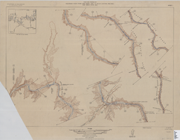
Map of plan and profile of Colorado River from Lees Ferry, Arizona to Black Canyon, Arizona-Nevada and Virgin River, Nevada, 1924
Date
1924
Archival Collection
Description
1 map in 21 sheets (14 plans, 7 profiles): col. ; 46 x 64 cm. Notes Relief shown by contours. Each sheet includes a key map. Surveys for individual sheets conducted 1919-23. Library has: Sheets I (2 copies), J, K, L, M, and N only. "Contour interval on land 50 feet." "Contour interval on river surface 5 feet." "Datum is mean sea level." "Mileage is measured from U. S. G. S. concrete gauge well opposite mouth of Paria River." "Topography by U. S. Reclamation Service." "Surveyed in 1919-23." Original publisher: U.S. Geological Survey, Scale: 1: 81,680.
Image