Search Results
Mormon Fort, Las Vegas, Nevada, 1925
Level of Description
File
Archival Collection
Florence Lee Jones Cahlan Photographs
To request this item in person:
Collection Number: PH-00045
Collection Name: Florence Lee Jones Cahlan Photographs
Box/Folder: Folder 01
Collection Name: Florence Lee Jones Cahlan Photographs
Box/Folder: Folder 01
Archival Component
Lease to Nevada Lime and Rock Company, 1925
Level of Description
File
Archival Collection
Union Pacific Railroad Collection
To request this item in person:
Collection Number: MS-00397
Collection Name: Union Pacific Railroad Collection
Box/Folder: Box 93
Collection Name: Union Pacific Railroad Collection
Box/Folder: Box 93
Archival Component
Arden, Nevada - Blue Diamond Spur, 1925
Level of Description
File
Archival Collection
Union Pacific Railroad Collection
To request this item in person:
Collection Number: MS-00397
Collection Name: Union Pacific Railroad Collection
Box/Folder: Box 22
Collection Name: Union Pacific Railroad Collection
Box/Folder: Box 22
Archival Component
Mining and Oil - Nevada, general, 1920-1925
Level of Description
File
Archival Collection
Union Pacific Railroad Collection
To request this item in person:
Collection Number: MS-00397
Collection Name: Union Pacific Railroad Collection
Box/Folder: Box 08
Collection Name: Union Pacific Railroad Collection
Box/Folder: Box 08
Archival Component
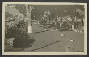
Photograph of a park in Caliente, Nevada, circa 1925
Date
1923 to 1927
Archival Collection
Description
View of a park in Caliente, Nevada. The Union Pacific Railroad Company's facilities (including coaling tower) are seen in the background on the left.
Image
Vegetation, approximately 1925 July to 1925 September
Level of Description
File
Archival Collection
Chester R. Longwell Professional Papers
To request this item in person:
Collection Number: MS-00017
Collection Name: Chester R. Longwell Professional Papers
Box/Folder: Box 02
Collection Name: Chester R. Longwell Professional Papers
Box/Folder: Box 02
Archival Component
Caliente, Nevada, 1900-1946
Level of Description
File
Archival Collection
Dorothy Ray Photograph Collection on Southern Nevada
To request this item in person:
Collection Number: PH-00161
Collection Name: Dorothy Ray Photograph Collection on Southern Nevada
Box/Folder: N/A
Collection Name: Dorothy Ray Photograph Collection on Southern Nevada
Box/Folder: N/A
Archival Component
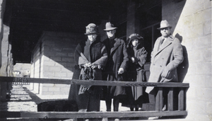
Photograph of people standing on a porch in Rhyolite, Nevada, February 1925
Date
1925-02
Archival Collection
Description
Identification given with photograph: "Rhyolite depot, in Rhyolite, Nevada February 1925. L-R: C. P. Squires, C. C. Boyer, Mrs. C. C. Boyer, James Cashman." Identification may be inaccurate.
Image
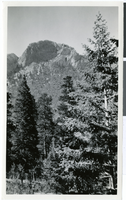
Photograph of Mt. Charleston, Nevada, circa 1925
Date
1925
Archival Collection
Description
Black and white photograph of trees and landscape on Mt. Charleston.
Image