Search Results
Goldfield Consolidated Mine, a two-week ore run worth $534,500.00. Handwritten note on back: photographic print, approximately 1900-1910
Level of Description
Archival Collection
Collection Name: C. A. Earle Rinker Photograph Collection of Goldfield, Nevada
Box/Folder: Folder 06
Archival Component
"The Wandering Moses 40 years in the desert." The postcard shows a man with a pack mule and several men standing behind him: postcard, approximately 1900-1915
Level of Description
Archival Collection
Collection Name: C. A. Earle Rinker Photograph Collection of Goldfield, Nevada
Box/Folder: Folder 03
Archival Component
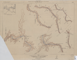
Map of plan and profile of Colorado River from Lees Ferry, Arizona to Black Canyon, Arizona-Nevada and Virgin River, Nevada, 1924
Date
Archival Collection
Description
Image
"Early Las Vegans: Jimmy & Lola Adams & daughter. Bessie Rockwell (behind Earl), Earl Rockwell, Margie and Leon Jr." (written on verso): photographic print, approximately 1915 to 1925
Level of Description
Archival Collection
Collection Name: Leon Rockwell Photograph Collection
Box/Folder: Folder 20
Archival Component
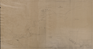
Map of general plan for the Wells Siding Project in Logandale, Nevada, May 15, 1935
Date
Archival Collection
Description
Image
C. A. Earle Rinker Photograph Collection of Goldfield, Nevada
Identifier
Abstract
The C. A. Earle Rinker Photograph Collection of Goldfield, Nevada (approximately 1900-1915) contains individual black-and-white photographic prints, photographic albums, black-and-white and tinted postcards, and photographic negatives that document the history of early twentieth century Goldfield, Nevada. The images include photographic prints of Goldfield and surrounding areas during its peak years of 1906-1910; postcards showing scenes of Goldfield, Tonopah, and other areas in central Nevada; and negatives that contain images of Rinker's family and homelife in Indiana and Illinois.
Archival Collection
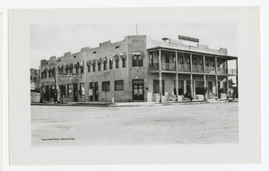
Photograph of Hotel Nevada, Las Vegas (Nev.), 1912
Date
Archival Collection
Description
Image
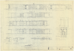
Architectural drawings of a residential home in Las Vegas, Nevada, November 2, 1962
Date
Description
Exterior elevations and details for a residential home on Fifth Place in Las Vegas, Nevada. Sheet no. 4. "Drw. D.H."
Architecture Period: Mid-Century ModernistImage
UNLV University Libraries Collection on Nevada Mining
Identifier
Abstract
The Nevada Mining Collection is comprised of records that document mining and mines in Nevada from 1842 to 1966. The majority of the collection includes records of various mines and mining companies located in the Esmeralda, Lincoln, Clark, White Pine, and Nye counties, dating from 1900 to 1928. The collection includes financial, administrative, and business related records; photographs of miners, mining camps, and towns; correspondence; maps; newspaper clippings, pamphlets, newsletters, and booklets.
Archival Collection
The Golden Treasury of the best songs and lyrical poems in the English language. London: George Routledge & Sons, Ltd., approximately 1900 to 1909
Level of Description
Archival Collection
Collection Name: Mavis Eggle "Books as They Were Bought" Collection
Box/Folder: No Container 00
Archival Component