Search Results

Tonopah, Nevada mining map, March 1904
Date
Description
Text

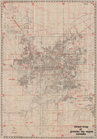
Street map of greater Las Vegas, Nevada, 1965-1966
Date
Description
Image

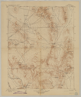
Geology of the Jackass Flats quadrangle, Nye County, Nevada, 1964
Date
Description
Image
Street map of greater Las Vegas, Nevada, 1984
Date
Description
Text

Map showing detailed topography of the country traversed by the reconnaissance expedition through southern & southeastern Nevada, 1869
Date
Description
no. 1.miles. Library's copy has counties hand-outlined in colored markers.
Image

Map of Las Vegas, Nevada, July 1947
Date
Description
'Prepared by Porter & White Agency. Typography by Marc Wilkinson.' 'Travel-Aid. A Ballinger publication, copyright, July 1947.' Panel title: 'Las Vegas, Nevada invites you! : see Boulder Dam, Lake Mead.' Includes information on Las Vegas, business directory, advertisements and directory of service clubs. Advertisements, map of Boulder City, and map of southern Nevada area with advertisements on verso. Ballinger Publishing Company.
Text
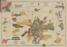
Map of Tonopah Mining District, Nevada, revised edition, 1903
Date
Description
Image
Map of Kawich Quadrangle, Nye County, Nevada, June 1908
Date
Description
Text

Official Arrow city map, Las Vegas & vicinity, Nevada, circa 1957-1961
Date
Description
71 x 68 cm. on sheet 106 x 71 cm., folded in cover 25 x 12 cm. Cover title: Latest edition, city map and street index of "fabulous" Las Vegas and vicinity, Nevada. Publisher from cover. "H-654-32." Includes indexes. Inside of cover includes information on Las Vegas. Includes inset maps of Boulder City, Nevada, and Las Vegas's location. Original publisher: R. L. Polk.
Image
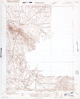
Map of Ely Range Quadrangle, Lincoln County, Nevada, 1921
Date
Description
'Edition of 1921.' 'W. H. Herron, Acting Chief Geographer; Geo. R. Davis, Geographer In Charge; Topography by H. H. Hodgeson, N. E. Ballmer, and W. B. Upton, Jr.; Control by H. H. Hodgeson, Roscoe Reeves, and D. S. Birkett. Surveyed in 1916.' At top of map: ' Topography, State of Nevada.' At upper left corner: ' Department of the Interior, Albert B. Fall, Secretary; U.S. Geological Survey, George Otis Smith, Director.' Southern Nevada Mining Map Collection. 15 minute series (topographic) Nevada.
Image