Search Results
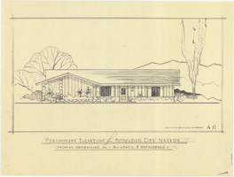
Architectural drawing of residential home in Boulder City, Nevada, preliminary elevation, 1962
Date
1962
Archival Collection
Description
Preliminary drawing of front exterior elevation of a ranch-style residential home in Boulder City, Nevada.
Architecture Period: Mid-Century ModernistImage
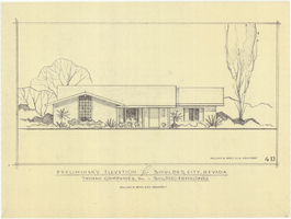
Architectural drawing of residential home in Boulder City, Nevada, preliminary elevation, 1962
Date
1962
Archival Collection
Description
Preliminary drawing of front exterior elevation of a ranch-style residential home in Boulder City, Nevada.
Architecture Period: Mid-Century ModernistImage
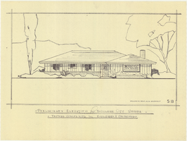
Architectural drawing of residential home in Boulder City, Nevada, preliminary elevation, 1962
Date
1962
Archival Collection
Description
Preliminary drawing of front exterior elevation of a ranch-style residential home in Boulder City, Nevada.
Architecture Period: Mid-Century ModernistImage
Reproduction of an original image from early 1900s of Lois Kellogg posed in a regal outfit: photographic print, approximately 1950 to 1990
Level of Description
Item
Archival Collection
Denny Lynch Photograph Collection
To request this item in person:
Collection Number: PH-00255
Collection Name: Denny Lynch Photograph Collection
Box/Folder: Folder 05
Collection Name: Denny Lynch Photograph Collection
Box/Folder: Folder 05
Archival Component
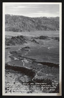
Postcard showing view from Mount Whitney Highway across Owens Valley, Lone Pine, California, circa mid 1900s
Date
1920 to 1959
Archival Collection
Description
An image of the Mount Whitney Highway across Owens Valley in Lone Pine, California. Transcribed upon the bottom of the image: "View from new Mt. Whitney Highway across Owens Valley, Alabama Hills, oldest formations in U.S. middle distance, Lone Pine, California."
Image
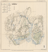
Generalized hydrogeologic map of lower Moapa-Lake Mead area, Clark County, Nevada, 1968
Date
1968
Description
'Hydrogeology by F.E. Rush, 1968. Geology adapted from Longwell and others 1965.' In lower left corner: ' Base: U.S. Geological Survey 1:250,000 topographic series; Las Vegas (1954).' At top of map: 'United States Department of the Interior, Geological Survey. Department of Conservation and Natural Resources, State of Nevada.' Relief shown by contoursIncludes township and range lines. Scale 1:250,000 (W 115°00´--W 114°15´/N 36°30´--N 36°15´). Series: Water resources-reconnaissance series report . Originally published as plate 1 in Water-resources appraisal of the lower Moapa-Lake Mead area, Clark County, Nevada / by F. Eugene Rush, published by State of Nevada Dept. of Conservation and Natural Resources in 1968 in volume 50 of the serial Water resources-reconnaissance series report.
Image
Men of the Rochester-Goldfield Mining Company sit in horse-drawn wagons. Rinker is seated in first wagon: photographic print, approximately 1900-1910
Level of Description
Item
Archival Collection
C. A. Earle Rinker Photograph Collection of Goldfield, Nevada
To request this item in person:
Collection Number: PH-00350
Collection Name: C. A. Earle Rinker Photograph Collection of Goldfield, Nevada
Box/Folder: Folder 05
Collection Name: C. A. Earle Rinker Photograph Collection of Goldfield, Nevada
Box/Folder: Folder 05
Archival Component
"Fishing trip near Moapa. Early Las Vegans: Ray Mosbach family, Jim Adams family, Leon Rockwell, Sr. family" (written on verso): photographic print, approximately 1915 to 1925
Level of Description
Item
Archival Collection
Leon Rockwell Photograph Collection
To request this item in person:
Collection Number: PH-00008
Collection Name: Leon Rockwell Photograph Collection
Box/Folder: Folder 20
Collection Name: Leon Rockwell Photograph Collection
Box/Folder: Folder 20
Archival Component
Haller, Mark H. Bootleggers as Businessmen: From City Slums to City Builders, Law, Alcohol, and Order: perspectives on national prohibition, approximately 1900 to 1999
Level of Description
File
Archival Collection
UNLV Libraries Collection of Articles on Gaming and Las Vegas, Nevada Topics
To request this item in person:
Collection Number: MS-00626
Collection Name: UNLV Libraries Collection of Articles on Gaming and Las Vegas, Nevada Topics
Box/Folder: Box 19
Collection Name: UNLV Libraries Collection of Articles on Gaming and Las Vegas, Nevada Topics
Box/Folder: Box 19
Archival Component
Butterfield, Roger. Harold's Club: Country's biggest gambling joint run by Smith family of Reno, Life 19(16), approximately 1900 to 1999
Level of Description
File
Archival Collection
UNLV Libraries Collection of Articles on Gaming and Las Vegas, Nevada Topics
To request this item in person:
Collection Number: MS-00626
Collection Name: UNLV Libraries Collection of Articles on Gaming and Las Vegas, Nevada Topics
Box/Folder: Box 10
Collection Name: UNLV Libraries Collection of Articles on Gaming and Las Vegas, Nevada Topics
Box/Folder: Box 10
Archival Component