Search Results
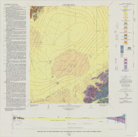
Geologic map of the Frenchman Flat quadrangle, Nye, Lincoln, and Clark Counties, Nevada, 1965
Date
Description
Image
Portraits and group photographs of Eileen Lancaster's family in Bradford, England; Hamburg, Germany; Iowa; and Kentucky: photographic prints, approximately 1813 to 1900
Level of Description
Archival Collection
Collection Name: Eileen Lancaster Family Photographs
Box/Folder: Box SH-084
Archival Component
Team of burros pull wagons loaded with material; The Pullman and White's Hotel visible in the background, : glass plate negative, approximately 1900 to 1909
Level of Description
Archival Collection
Collection Name: E. W. Smith Glass Plate Negatives
Box/Folder: Box 01
Archival Component
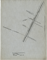
Map showing water pipeline serving H. C. Wheeler, Arden, Nevada, November 1929
Date
Archival Collection
Description
Image
Hazel Denton's brother Ralph Baker sitting on the wooden stairs of a porch with a child on his lap: photographic print, approximately 1900-1965
Level of Description
Archival Collection
Collection Name: Hazel Baker Denton Photograph Collection
Box/Folder: Folder 02
Archival Component
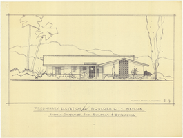
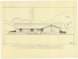
Architectural drawing of residential home in Boulder City, Nevada, preliminary elevation, 1962
Date
Archival Collection
Description
Preliminary drawing of front exterior elevation of ranch-style residential home in Boulder City, Nevada.
Architecture Period: Mid-Century ModernistImage
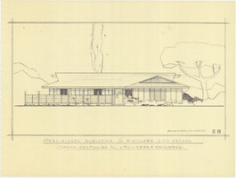
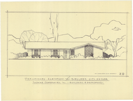
Architectural drawing of residential home in Boulder City, Nevada, preliminary elevation, 1962
Date
Archival Collection
Description
Preliminary drawing of front exterior elevation of a ranch-style residential home in Boulder City, Nevada.
Architecture Period: Mid-Century ModernistImage
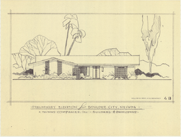
Architectural drawing of residential home in Boulder City, Nevada, preliminary elevation, 1962
Date
Archival Collection
Description
Preliminary drawing of front exterior elevation of a ranch-style residential home in Boulder City, Nevada.
Architecture Period: Mid-Century ModernistImage
Architectural drawing of residential home in Boulder City, Nevada, preliminary elevation, 1962
Date
Archival Collection
Description
Preliminary drawing of front exterior elevation of a ranch-style residential home in Boulder City, Nevada.
Architecture Period: Mid-Century ModernistImage
Architectural drawing of residential home in Boulder City, Nevada, preliminary elevation, 1962
Date
Archival Collection
Description
Preliminary drawing of front exterior elevation of a ranch-style residential home in Boulder City, Nevada.
Architecture Period: Mid-Century ModernistImage