Search Results

Map of Las Vegas and vicinity, Clark County, Nevada, November 1952
Date
Description
Image
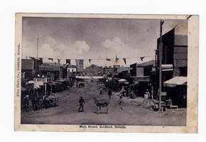
Main Street, Goldfield, Nevada, postcard
Description

Surficial geologic map of the Specter Range NW quadrangle, Nye County, Nevada, 1989
Date
Description
Image
Southern Nevada Educators Photograph Collection
Identifier
Abstract
The Southern Nevada Educators Photograph Collection consists of reproduction black-and-white photographic prints and negatives that Donna Andress compiled. The majority of the images are portraits of educators in Southern Nevada, primarily educators who have schools in Clark County, Nevada named after them. Other portraits depict prominent Las Vegas citizens, including Leva and William Beckley.
Archival Collection

Map showing second stage plan of development for Southern Nevada Water Project, March 1981
Date
Description
Image
George Lockhart in his office. His right hand is wrapped in gauze. The inscription on the back of the photo reads: "George Lockhart, son of Thomas Lockhart, owner of Florence Mine, Goldfield, Nevada. In office where I worked for Davis & Shoemaker": photographic print, approximately 1900-1915
Level of Description
Archival Collection
Collection Name: C. A. Earle Rinker Photograph Collection of Goldfield, Nevada
Box/Folder: Folder 02
Archival Component
William V. Wright Collection of Nevada Postcards
Identifier
Abstract
The William V. Wright Collection of Nevada Postcards contains picture postcards of towns and buildings in Nevada from 1900 to 1975. The postcards primarily depict casinos, hotels, and other attractions in Las Vegas, Nevada and Reno, Nevada. The postcards also depict post offices, landscapes, mines, and the Hoover (Boulder) Dam.
Archival Collection
Photographic print, annotated: "Arrival of Tex Rickards' drill for mining and water, Rawhide Northern Water Company." Handwritten note on back: photographic print, approximately 1900-1915
Level of Description
Archival Collection
Collection Name: C. A. Earle Rinker Photograph Collection of Goldfield, Nevada
Box/Folder: Folder 06
Archival Component
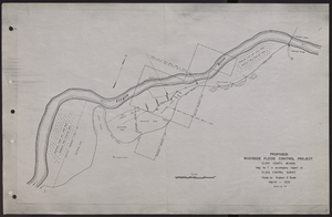
Map of proposed flood control project on the Virgin River in Clark County, Nevada, March, 1934
Date
Archival Collection
Description
Image