Search Results

Film transparency of a group picnicking at the Old Ranch, Las Vegas, circa early 1900s
Date
Archival Collection
Description
Image

Map of Argentite Red Mountain Mining District, Esmeralda County, Nevada, circa 1908-1913
Date
Description
Image
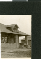
Photograph of Mrs. Park at John S. Park's home, Las Vegas, circa early 1900s
Date
Archival Collection
Description
Image
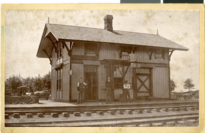
Photograph of men in front of building, Gilliam, Missouri, circa late 1800s to early 1900s
Date
Archival Collection
Description
Image

Original plat, townsite of Las Vegas, Lincoln Co., Nevada, January 13, 1905
Date
Description
Subtitle: 'Embracing the N. 1/2 of S.W. 1/4 Sec. 27 Township 20S. R.61E. Mt. Diablo Meridian.' 'Book 1, page 17A" handwritten in lower right corner. Signed by Henry Lee, County Recorder, Lincoln County Nevada. 'Filed at request of J.T. Williams, January 13th A.D. 1905.' Backwards handwriting on right side. Map has a Lincoln County seal on the bottom near the center. In the dedication J.T. McWilliams states that he has surveyed and platted the townsite of Las Vegas subject to the right of way of the San Pedro, Los Angeles and Salt Lake Railroad Company. He signed the dedication on Jan. 13, 1905, and it was signed by witnesses Scale [ca. 1:2,520? 1 inch to approx. 210 feet?]. Copy of a blueline print.
Image
Photocopies of 1925-1929 CRC Pittman documents regarding the Boulder Canyon Project Act and detailed memorandum, 1981 November 11
Level of Description
Archival Collection
Collection Name: Colorado River Commission of Nevada Reference Library Collection
Box/Folder: Box 11
Archival Component

Map of Las Vegas Valley, Clark County, Nevada, 1954
Date
Description
Image
Grandmother Daisy Beldam (Rex Bell's mother) with Rex Anthony Bell, Jr (Toni Larbow Beldam) as an infant, approximately 1925 to 1935
Level of Description
Archival Collection
Collection Name: University of Nevada, Las Vegas Creative Services Records (2010s)
Box/Folder: Digital File 00
Archival Component
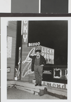
Photograph of an unidentified man in front of Lady Luck Casino, Las Vegas, circa early to mid 1900's
Date
Archival Collection
Description
Image

Map of city of Las Vegas, Nevada, October 1, 1940
Date
Description
Image