Search Results
Nevada Mining Photograph Collection
Identifier
Abstract
The Nevada Mining Photograph Collection depicts mining activities, miners, and mining towns in Nevada from 1868 to 1937. The photographs primarily depict the towns of Tonopah, Nevada and Goldfield, Nevada, including mills, buildings, mine shafts, and panoramic views of the landscape. The photographs also depict Beatty, Lost City, Delamar, Candelaria, Winnemucca, Virginia City, Rhyolite, Elko, and Reno, Nevada. The photographs also include portraits of early settlers in Nevada, Native Americans, children, parades, celebrations, and funerals.
Archival Collection

A Nevada Desert Experience sign: photographic print
Date
Archival Collection
Description
Image
University of Nevada, Las Vegas Faculty Publications
Identifier
Abstract
The University of Nevada, Las Vegas (UNLV) Faculty Publications (1950-2008) is comprised of reports, scholarly journal articles, and books that were written by UNLV faculty and staff. Publications also include book reviews and conference presentations. Subjects include biology, chemistry, English, and sociology.
Archival Collection

Map of Nevada Test Site: photographic print
Date
Archival Collection
Description
Image
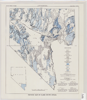
Tectonic map of Clark County, Nevada, 1965
Date
Description
62.
Image
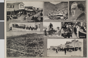
Postcard of scenes of Goldfield, Nevada and Gold Hill, Nevada, circa 1910s
Date
Archival Collection
Description
Image
Southern Nevada Gem and Mineral Society Records
Identifier
Abstract
The Southern Nevada Gem and Mineral Society Records (1950-2024) contain the records of the Clark County Gem Collectors, Las Vegas Gem Collectors, and the current Southern Nevada Gem and Mineral Society. The collection contains articles of incorporation, by-laws, membership directories, meeting minutes, correspondence, financial records, show paperwork, and award certificates. Also included are photographs of the organizations since the 1970s and digital scans of Gem Times and The Polished Slab newsletters.
Archival Collection
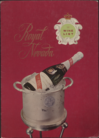
Royal Nevada wine list
Date
Archival Collection
Description
Note: No date on menu Menu insert: Wine lists Restaurant: Royal Nevada Location: Las Vegas, Nevada, United States
Text
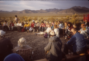
Protesters seated in the desert at Nevada Test Site, Nevada: photographic slide
Date
Archival Collection
Description
From the Sister Klaryta Antoszewska Photograph Collection (PH-00352). Demonstration at Nevada Test Site
Image
University of Nevada, Las Vegas Web Archive
Identifier
Abstract
The University of Nevada, Las Vegas (UNLV) Web Archive represents archived websites that are part of the unlv.edu domain that have been collected since 2013. Websites in this collection represent all academic functions of UNLV including colleges and departments, the University Libraries, museums, undergraduate and graduate colleges, and course catalogs. Other websites represented in this collection include UNLV Athletics, research centers, campus directories, UNLV News Center, and the UNLV President's website.
Archival Collection