
Search the Special Collections and Archives Portal

Search Results

Display    Results Per Page
Displaying results 6761 - 6770 of 579530

Geologic map of the Lathrop Wells quadrangle, Nye County, Nevada, 1970

Date

1970

Description

58 x 47 cm., on sheet 74 x 84 cm., folded in envelope 30 x 24 cm. Relief shown by contours and spot heights. "Bedrock geology mapped by B.C. Burchfiel, 1961, and by E.J. McKay and K.A. Sargent, 1965-66. Surficial geology mapped by A.T. Fernald, 1968." Includes cross sections, description of map units, and location map. "Prepared in cooperation with the U. S. Atomic Commission." Original publisher: Interior, Geological Survey, Series: Geologic quadrangle map GQ, Scale: 1:24 000.

Image

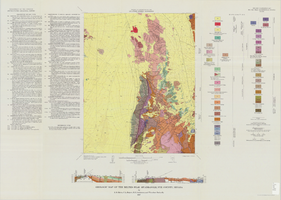
Geologic map of the Topopah Spring quadrangle, Nye County, Nevada, 1970

Date

1970

Description

58 x 46 cm., on sheet 84 x 88 cm., folded in envelope 30 x 24 cm. Relief shown by contours and spot heights. "Geology mapped in 1962-63." Includes description of map units, colored columnar section, 3 colored cross sections, and quadrangle location map. "Prepared in cooperation with the U. S. Atomic Commission." Original publisher: Interior, Geological Survey, Series: Geologic quadrangle map GQ, Scale: 1:24 000.

Image

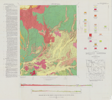
Geologic map of the Tippipah Spring quadrangle, Nye County, Nevada, 1963

Date

1963

Description

58 x 46 cm., on sheet 84 x 81 cm., folded in envelope 30 x 24 cm. Relief shown by contours and spot heights. "Geology by P.P. Orkild, 1959-60, paleotopography by D.L. Healey and C.H. Miller, 1959-60." Series statement from envelope. Includes description of map units, 2 col. cross sections, and quadrangle location map. "Prepared in cooperation with the U. S. Atomic Commission." Original publisher: Interior, Geological Survey, Series: Geologic quadrangle map GQ, Scale: 1:24 000.

Image

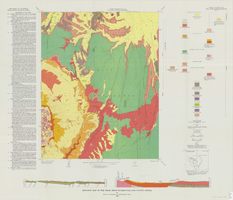
Geologic map of the Ammonia Tanks quadrangle, Nye County, Nevada, 1967

Date

1967

Description

58 x 46 cm., on sheet 84 x 100 cm., folded in envelope 30 x 24 cm. Relief shown by contours and spot heights. "Base by U.S. Geological Survey, 1961." "Geology mapped in 1961-65." "Contour interval 20 feet." Includes 3 col. cross sections, 1 index map, text with bibliography, and quadrangle location map. "Prepared in cooperation with the U. S. Atomic Commission." Original publisher: Interior, Geological Survey, Series: Geologic quadrangle map GQ, Scale: 1:24 000.

Image

Geologic map of the Belted Peak quadrangle, Nye County, Nevada, 1967

Date

1967

Description

45 x 36 cm., on sheet 64 x 89 cm., fold. in envelope 30 x 24 cm. Relief shown by contours and spot heights. "Contour interval 40 feet." "Prepared in cooperation with the U.S. Atomic Energy Commission." "Geology mapped in 1962-63." Includes text, 2 col. cross sections, and quadrangle location map. Original publisher: U.S. Geological Survey, Series: Geologic quadrangle map GQ, Scale: 1:62 500.

Image

Geologic map of the Thirsty Canyon quadrangle, Nye County, Nevada, 1966

Date

1966

Description

57 x 46 cm., on sheet 83 x 91 cm., folded in envelope 30 x 24 cm. Relief shown by contours and spot heights. "Geology mapped in 1963." Includes 2 colored cross sections, index map, text, and quadrangle location map. "Prepared in cooperation with the U. S. Atomic Commission." Original publisher: Interior, Geological Survey, Series: Geologic quadrangle map GQ, Scale: 1:24 000.

Image

Geologic map of the Trail Ridge quadrangle, Nye County, Nevada, 1968

Date

1968

Description

58 x 46 cm., on sheet 79 x 91 cm., folded in envelope 30 x 24 cm. Relief shown by contours and spot heights. "Prepared in cooperation with the U.S. Atomic Energy Commission." "Base by U.S. Geological Survey, 1962." "Geology mapped in 1963." "Contour interval 20 feet." Includes text, 2 col. cross sections, quadrangle location map, and 1 index map. Original publisher: Interior, Geological Survey, Series: Geologic quadrangle map GQ, Scale: 1:24 000.

Image

Nevada Biltmore Hotel Collection

Identifier

MS-00479

Abstract

The collection dates from 1942 to 1986 and contains a scrapbook and other materials related to the Nevada Biltmore built by Robert Brooks in Las Vegas, Nevada. The scrapbook includes photographs of the resort and newspaper clippings. It also contains some materials from the Seven Seas restaurant owned by Brooks in Hollywood, California. The collection includes newspaper clippings related to Las Vegas gaming and politics, some photographs of Bob Brooks and his wife Jewel at social events in Las Vegas, and a Biltmore menu and stationary.

Archival Collection

UNLV University Libraries Collection on Nevada Mining

Identifier

MS-00011

Abstract

The Nevada Mining Collection is comprised of records that document mining and mines in Nevada from 1842 to 1966. The majority of the collection includes records of various mines and mining companies located in the Esmeralda, Lincoln, Clark, White Pine, and Nye counties, dating from 1900 to 1928. The collection includes financial, administrative, and business related records; photographs of miners, mining camps, and towns; correspondence; maps; newspaper clippings, pamphlets, newsletters, and booklets.

Archival Collection

Centennial Stories: A Leap Back, A Look Forward-100 Years of History-The Strip, CCTV-4 Clark County TV, 2009

Level of Description

File

Archival Collection

Scott Rayer Collection of Television Programs about Las Vegas, Nevada
To request this item in person:
Collection Number: MS-01130
Collection Name: Scott Rayer Collection of Television Programs about Las Vegas, Nevada
Box/Folder: Digital File 00

Archival Component